Route Editor

| Guide | ♦ | 3 Triplogs | 0 Topics |
details | drive | no permit | forecast | route |
stats |
photos | triplogs | topics | location |
| 15 | 3 | 0 |
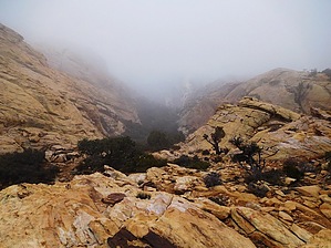
Welcome to Somewhere by LindaAnn  Details: There is a dirt parking area on the north side of the highway, with room for about a dozen cars. There are a few dirt roads at this lot, make sure not to block any private drives.
After another 0.5 miles, the trail forks at a cairn. You will take the right fork and head east again. The trail got a little faint in places through here, but it seemed like it always picked up again or a cairn was visible ahead, and generally headed east, slightly southeast. Every so often, the views opened up to the north, which provided great picture taking opportunities. Near the end of the trail, the rocks changed to a yellow & orange color, and the trail headed down to a saddle. The views to the east were incredible. There was plenty of room to scramble around on the rocks for various vantage points. This was the end of the easy trail, but if you to continue scrambling (Class 3 in places after that) to the southeast, you would end up at the summit of Windy Peak. It was wet and foggy the day I was here, so the saddle was my turnaround point. Return to the trailhead the way you came up. There are several other trails that branch off this main trail, including one that heads north from that fork 1.5 miles in which seems to follow the ridgeline for a while. Gate Policy: If a gate is closed upon arrival, leave it closed after you go through. If it is open, leave it open. Leaving a closed gate open may put cattle in danger. Closing an open gate may cut them off from water. Please be respectful, leave gates as found. The exception is signage on the gate directing you otherwise. Check out the Official Route and Triplogs. Leave No Trace and +Add a Triplog after your hike to support this local community. | ||||||||||||||||||||||||||||||||||||||||||||||||||||||||||||||||||||||||||||||||||