 Route Editor

| Guide | ♦ | 2 Triplogs | 0 Topics |
details | drive | no permit | forecast | map |
stats |
photos | triplogs | topics | location |
| 22 | 2 | 0 |
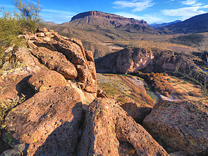
 Remote scenic Indian ruin site located along the Salt River within the Salt River Canyon Wilderness. The ruins are perched atop a tall, steep, rugged butte on a gooseneck river bend. Reaching the ruins requires class 3 scrambling. Access from the TH is by land or by river. Land access requires crossing the Salt River. The best time of year to hike this site is in fall or winter during low river flow. An excellent destination for those with a love for ancient Indian history and off-trail adventure. Remote scenic Indian ruin site located along the Salt River within the Salt River Canyon Wilderness. The ruins are perched atop a tall, steep, rugged butte on a gooseneck river bend. Reaching the ruins requires class 3 scrambling. Access from the TH is by land or by river. Land access requires crossing the Salt River. The best time of year to hike this site is in fall or winter during low river flow. An excellent destination for those with a love for ancient Indian history and off-trail adventure.
Check out the Triplogs. Leave No Trace and +Add a Triplog after your hike to support this local community. One-Way Notice This hike is listed as One-Way. When hiking several trails on a single "hike", log it with a generic name that describes the hike. Then link the trails traveled, check out the example. | |||||||||||||||||||||||||||||||||||||||||||||||||||||||||||||||||||||


