Route Editor

| Guide | ♦ | 2 Triplogs | 0 Topics |
details | drive | permit | forecast | route |
stats |
photos | triplogs | topics | location |
| 25 | 2 | 0 |
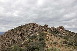
terrain is excellent by GeeEss   The high point of the Arrastra Mountain Wilderness is a surprisingly easy target, save that last 100', which we were unable to manage. Pretty tough drive required high clearance 4WD. Start hiking along an old road toward the obvious high point in the region until the road reaches the Arrastra ridgeline, at which point you hang a right and head right on up. The off-trail route is obvious and the terrain is excellent, with no serious impediments until very near the peak, at which point, narrow routes, and severe underbrush become an untenable problem. Don't get me wrong, the peak is attainable if you're motivated enough to plant your flag, but we just weren't interested in killing an hour or two for that last 100' elevation. Close enough I say! The high point of the Arrastra Mountain Wilderness is a surprisingly easy target, save that last 100', which we were unable to manage. Pretty tough drive required high clearance 4WD. Start hiking along an old road toward the obvious high point in the region until the road reaches the Arrastra ridgeline, at which point you hang a right and head right on up. The off-trail route is obvious and the terrain is excellent, with no serious impediments until very near the peak, at which point, narrow routes, and severe underbrush become an untenable problem. Don't get me wrong, the peak is attainable if you're motivated enough to plant your flag, but we just weren't interested in killing an hour or two for that last 100' elevation. Close enough I say!Return to the road then keep heading west if you crave a more robust hike. Not sure the road will get you all the way to the Big Sandy, but it appears to continue into the wilderness for at least three more miles. Check out the Official Route and Triplogs. Leave No Trace and +Add a Triplog after your hike to support this local community. | ||||||||||||||||||||||||||||||||||||||||||||||||||||||||||||||||||||||||||||||||||||||||||||||||