Route Editor

| Guide | ♦ | 2 Triplogs | 0 Topics |
details | drive | no permit | forecast | 🔥 route |
stats |
photos | triplogs | topics | location |
| 20 | 2 | 0 |
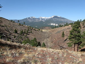
Cut O'Leary in half by hippiepunkpirate   Robinson Mountain is a small subsidiary peak of O'Leary. While O'Leary is not incredibly interesting, Robinson is even less interesting. However, if you're in the Sunset Crater area and you don't have time for O'Leary but want a decent climb up a volcano that isn't quite a cinder cone, Robinson works out just fine. Robinson Mountain is a small subsidiary peak of O'Leary. While O'Leary is not incredibly interesting, Robinson is even less interesting. However, if you're in the Sunset Crater area and you don't have time for O'Leary but want a decent climb up a volcano that isn't quite a cinder cone, Robinson works out just fine.The day I did Robinson was originally planned as an ascent to the O'Leary summit. The night before, I said I wouldn't even do a hike that day because I had a big presentation in the afternoon I needed to prepare for. But then I said, "Hey, the weather is going to be nice, and I could squeeze in a fast-paced early morning climb".
By the time I backtracked back to my camera, I had realized I probably wasn't going to have time to summit, but I didn't want to head back to the car. I whipped out my map and quickly found Robinson Mountain, elevation 7,911 feet. Perfect. Half as much elevation as O'Leary and not very far off the official trail. Basically, Robinson filled a niche: a gradual 1,000 foot climb in the Flagstaff area when the Peaks aren't quite in season. Hike Park at the O'Leary Trailhead. Hike up the O'Leary Trail and stop at the top of the first big switchback (elevation about 7400). An old forest service road actually splits off from here. There are three heavy gauge cables strung across the junction. Hop over them and continued up the old road. Eventually, you hit the Robinson ridgeline and another junction, this time with a more maintained forest road. Check out the view of the north section of the volcanic field, and then turn left and head up the ridgeline. The road steepens to climb a false summit (you can bypass the false summit, but it offers a view). At the false summit, leave the road and follow the ridgeline to the left to continue to Robinson. Staying on the road would take you along a ridgeline opposite of a small basin from Robinson. There is an intermittent trail along the rest of the ridge. It looks as if a low to medium-intensity fire came through some time, so it's pretty open, and you can't lose the ridge. Make sure to enjoy the views of the Peaks from the ridge because they are obscured at the summit. Also, be on the lookout for volcanic bombs along the ridge. At the summit, you get a nice view of the northern San Francisco Volcanic Field as well as Sunset Crater and the Bonito Lava Flow. Head back the way you came. Be careful about the roads up here. Descending, I accidentally took a different old road and ascended O'Leary a ways before I noticed where I was. Robinson Mountain won't knock your socks off, but it does offer some lovely views and bagging of an obscure peak. Plus, the old-growth forest and volcanic landscape are beautiful in their own right. It's more of a morning hike, so you get the superior light on the Peaks from the east. With the roads running about, I could see weekends having off-roaders around, but for the most part, it should offer some solitude as well. Honestly, you could probably drive the nearby forest roads and get within at least a mile of the summit, if not closer... but what's the fun in that? Check out the Official Route and Triplogs. Leave No Trace and +Add a Triplog after your hike to support this local community. | ||||||||||||||||||||||||||||||||||||||||||||||||||||||||||||||||||||||||||||||||||||||||||||||||||||||||||