Route Editor

| Guide | ♦ | 2 Triplogs | 0 Topics |
details | drive | no permit | forecast | route |
stats |
photo | triplogs | topics | location |
| 1 | 2 | 0 |
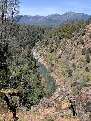
A Clear View of Clear Creek by lojones5  Piety Hill Loop is a part of the network of Cloverdale Trails at Clear Creek Greenway. The trail is dog-friendly. The area is a part of BLM Public Lands and provides outdoor trails for hiking, biking, and horseback riding. The two loop trails, Piety Hill Loop and Cloverdale Loop, each have a lookout point with a view of Clear Creek Canyon. Clear Creek Canyon also offers great whitewater kayaking. Near the Horsetown Clear Creek Preserve (near the lower Clear Creek Bridge), tubers and novice kayakers can have fun on the run to Clear Creek Gorge. Make sure to portage before (look for the signs) the Clear Creek Gorge, it is unrunnable and dangerous. Warning As always around these areas, watch out for poison oak. On this trail, also be aware of bikers and horses.
Keep an eye out for evidence of early gold mining in this area. Hike Much of the trail is within open grasslands and oak woodlands, with grass and wildflowers in the Spring. The trail is mostly flat and not too rugged. A great trail for hikers and mountain bikers as well. There are several views of Lassen in the distance, but the highlight of the trail is a fantastic overlook of Clear Creek Canyon.
Check out the Official Route and Triplogs. Leave No Trace and +Add a Triplog after your hike to support this local community. | |||||||||||||||||||||||||||||||||||||||||||||||||||||||||||||||||||||||||||||||||||||