username
X
password
register
for free!
help


Monolith Garden Lasso Loop, AZ

Guide 11 Triplogs  0 Topics
  2.5 of 5  
Fav
Wish
2
details
drive
no permit
forecast
route  
stats
photos
triplogs
topics
location
51 11 0
Statistics
tap row or icons for details
Difficulty 1 of 5
Route Finding 1 of 5
Distance Lasso-Loop 1.8 miles
Trailhead Elevation 3,680 feet
Elevation Gain 120 feet
Accumulated Gain 120 feet
Avg Time Round Trip 1 hour
Kokopelli Seeds 2.4
 Backpack Possible - Not Popular
feature photo
Photos Viewed All MineFollowing
10  2016-11-05 Tortoise_Hiker
4  2012-11-04 leonesiegel
22  2011-12-09 Stoic
5  2010-01-02 pwobbles
10  2009-04-24 AZLOT69
Author
author avatar Guides 177
Routes 249
Photos 10,213
Trips 2,215 map ( 17,459 miles )
Age 74 Male Gender
Location Gold Canyon, AZ
Associated Areas
list map done
Cerbat Foothills Recreation Area
Northwest Region
Historical Weather
Trailhead Forecast
Radar Map
Expand Map
Preferred Mar, Apr, Nov, Oct → 8 AM
Seasons   Early Autumn to Late Spring
Sun  6:11am - 6:59pm
Official Route
 
0 Alternative


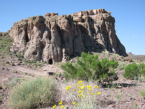
All The Elements Of A Garden
by AZLOT69

 
Overview
Just north of Kingman, Arizona is a beautiful desert landscape which proved to be worthy of a joint venture by the City of Kingman, the BLM, and the Arizona State Trail System. The investment in developing a series of multi-use trails results in a unique pay off for those willing to look outside the box of well-known trails. The area is now known collectively as the Cerbat Foothills Recreation Area. All the elements are here for a beautiful family-friendly desert garden hike, a great place to take a time out on the way to or from Las Vegas.


Hike
The trailhead has a restroom but no water available. Starting in a westerly direction, head towards the mountain on the old access road. A mine is visible almost immediately in that mountain, which is not visible from the highway. This is inviting and certainly needs exploration. What a suitable shelter if the need ever arose. In continuing around the mountain, a gate discourages any motor vehicles. It is equipped with an animal and pedestrian walk-thru. The landscape ahead will undoubtedly remind you of Monument Valley on a small scale.
remove free decal offer
The first intersection is marked clearly as a trail, going in either direction. Documented here in a clockwise direction, you will later see a series of loops of varying lengths. They are all marked as trail so pay attention to where you came. The hike offers total isolation from the busy highways east and south of this canyon, and there is no sign of civilization. Towering rock formations are all around, and the scenery is straight out of an old western movie. The trail is a single track. It would certainly present a great beginner mountain bike experience. Upon reaching the next intersection, there is a bench if you wish to relax and take it all in. Proceed to the right for a quarter-mile where another intersection appears. Taking another right will bring you back to where you started. The trail in and around the volcanic fields and rock outcroppings is surprisingly smooth. It will likely have you stopping to take advantage of different light conditions for potentially spectacular photos.

Gate Policy: If a gate is closed upon arrival, leave it closed after you go through. If it is open, leave it open. Leaving a closed gate open may put cattle in danger. Closing an open gate may cut them off from water. Please be respectful, leave gates as found. The exception is signage on the gate directing you otherwise.

2009-04-30 AZLOT69


    Check out the Official Route and Triplogs.
    Leave No Trace and +Add a Triplog after your hike to support this local community.
    WARNING! Hiking and outdoor related sports can be dangerous. Be responsible and prepare for the trip. Study the area you are entering and plan accordingly. Dress for the current and unexpected weather changes. Take plenty of water. Never go alone. Make an itinerary with your plan(s), route(s), destination(s) and expected return time. Give your itinerary to trusted family and/or friends.

     Permit $$
    None


     Directions
    or
     Road
    FR / Dirt Road / Gravel - Car Okay

    To hike
    U.S. 93 is a limited access divided highway north of Kingman. Access to this trailhead is from the southbound side two miles south of SR 68, one-quarter mile south of Coyote Pass. An unlocked chain link fence must be opened and closed to access the trailhead, which is in view at this point.
    page created by AZLOT69 on Apr 30 2009 11:12 am
     90+° 8am - 6pm kills
    helpcorrectionissue

    end of page marker