 Route Editor

| Guide | ♦ | 1 Triplog | 0 Topics |
details | drive | no permit | forecast | route |
stats |
photos | triplog | topics | location |
| 12 | 1 | 0 |
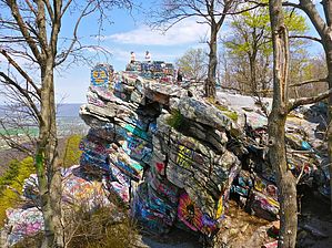
I did not get high at High Rock by kingsnake Starting at Wolfsville Rd., head west along the trail which parallels the paved road. Do not head up the dirt road at the back of the parking area: That leads to private property. Less than half a mile up the AT is the Ensign Cowall Shelter. According to WikiTrail.org, Ensign Cowall is a new shelter, intended to replace the “dismantled” Raven Rock Shelter.
Between late fall and early spring, when there are few leaves on the trees, if you look east four miles, you may be able to see Catoctin Mountain, home of the presidential retreat at Camp David. (Frankly, I am surprised it is even noted on the topo map.) If you hear shooting, it is probably not attacking jihadis, but rather the gun club just west on MD-77 / Foxville Rd. The unnamed creek through Warner Gap Hollow was flowing quite heavy. It would make a great filtering point for thru-hikers. With care, and maybe hiking poles, it can be crossed dry. This segment’s second climb begins after crossing dirt Warner Gap Hollow Rd.: 225 AEG in a third of a mile to a saddle below rocky Buzzard Knob. Little Antietam Creek is parallel to MD-491 between Buzzard Knob and Raven Rock. It can be crossed also be crossed dry with care, and maybe hiking poles. After crossing the road is this segment's third and steepest climb: 600 AEG in 0.6 miles. There are switchbacks, but it still felt quite steep. Raven Rock is the hill at the top of the climb, but from the AT, which passes just below the summit, it is not nearly as obvious as Buzzard Knob. From Raven Rock, the Appalachian Trail continue to to climb to High Rock, but the angle is barely noticeable. The Raven Rock Shelter is on Raven Rock’s shallow north slope, about 100 yds. to the west of the trail, hidden by trees. Despite internet rumors to the contrary, Raven Rock Shelter has not been dismantled. In fact, it is in great shape! It has an outhouse, bear box, picnic table, benches, fire ring and the shelter itself is clean. From Raven Rock Shelter, it is about 1.75 miles to High Rock. There is a signed intersection, and if you miss the first intersection, there is another about 150 yds. west on the AT. High Rock was covered with Dutch levels of graffiti. Thousands and thousands of tags. On all sides. Even in tricky heaven spots. It was crowded even mid-day on Friday, and is a popular "parking" and hang-gliding spot. (With a death toll to match.) From High Rock, the trail begins a steep, rocky descent. The path is so indistinct at times, and white blazes either missing or so faint, that the trail totally disappears. The fourth & final “climb” is 200 AEG in .80 miles, over trail that, again, often disappears in the rocky path. Thankfully, the final 1.5 miles from top of the climb into Pen Mar is slightly downhill on clear trail. Just across the railroad tracks, there is a sign and trail register marking the Mason-Dixon Line. Check out the Official Route and Triplog. Leave No Trace and +Add a Triplog after your hike to support this local community. One-Way Notice This hike is listed as One-Way. When hiking several trails on a single "hike", log it with a generic name that describes the hike. Then link the trails traveled, check out the example. | |||||||||||||||||||||||||||||||||||||||||||||||||||||||||||||||||||||||||||||||||||||


