 Route Editor

| Guide | ♦ | 122 Triplogs | 4 Topics |
details | drive | no permit | forecast | route |
stats |
photos | triplogs | topics | location |
| 792 | 122 | 4 |
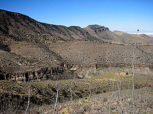
Remember the Alamo! by imike  Staying on the trail and climbing out of the narrow lower portion the canyon opens to broad meadows... moving with the stream into hardwoods, cedars then finally, away from the drainage and up the sides of the canyon into the towering pines and douglas firs of the upper range. At the far upper end the trail cuts sharply up the sides of the canyon to Alamo Peak at 9200'.
Beginning at the lower trailhead, you walk up the canyon drainage and into the wide, dry riverbed. This first 2.2 mile section is very open and sun exposed, and the trail signs have mostly been shot down by the locals. Simply follow the riverbed. At the end of that first section the drainage splits... you want to follow the right hand branch. (T103.. takes off up the left hand drainage at this point) For the next 4 odd miles there may not be a discernible path, but the narrow canyon bottom is easily maneuvered. At a point you will come to some old city waterworks ruins below a dramatic caprock overhang on the canyon wall. Above this is a large water puddle, followed by a slickrock slope... work your way up and out of the drainage on the left side. Above this area the trail leaves the stream bed and begins following or running near old city water drainage pipes. There is also an old mine works above the drainage on the left. After leaving the drainage bottom You will soon reach an intersection with an access road (for maintaining city water lines on the ridge far above to the north) and you turn right and continue up the canyon on this access road. This road will lead you up through some nice hardwood forest then out into a broad meadow... the largest of such in the Sacramento Mts. At the upper end of the meadow the trail crosses FR 90. You may either cross FR 90 and work your way up the right side of the meadow, eventually connecting at the far upper end of the meadow with T109... which will carry you on up the mountain to Alamo Peak, or you may turn to the right on FR 90 and connect with T109 at it's trailhead, shortly after leaving the meadow. It is 3 miles and 2,000' up to the Peak. The views are exceptional from the upper switchbacks, some of the only open views available from the higher ridge trails. The observatory on Alamo Peak is interesting... a big black globe... a bit scary when encountered unawares. Don't linger too long at the top... that's a long, hard hike back to the car. Note: This forest is subject to closure each spring due to high fire danger. check to make sure that the trail is open before attempting this route in May/June... although really it is too hot then anyway. Go somewhere else and play. Check out the Official Route and Triplogs. Note This is a moderately difficult hike. Leave No Trace and +Add a Triplog after your hike to support this local community. One-Way Notice This hike is listed as One-Way. When hiking several trails on a single "hike", log it with a generic name that describes the hike. Then link the trails traveled, check out the example. | |||||||||||||||||||||||||||||||||||||||||||||||||||||||||||||||||||||||||||||||||||||||||||||||


