Route Editor

| Guide | ♦ | 10 Triplogs | 0 Topics |
details | drive | no permit | forecast | route |
stats |
photos | triplogs | topics | location |
| 38 | 10 | 0 |
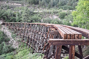
Walking the Ghost Line... by imike Page stats reflect #5001 one-way segment. The description below is 2.6 mi / 200 ft / 600 aeg / 1.5 hrs. The Cloud-Climbing Trestle Trail, including it's destination: the Mexican Canyon Trestle overlook, is the most popular tourist hiking destination in the Cloudcroft area. The Park Service has a picnic grounds, along with bathroom facility (...in the guise of a replica of the original Railway Depot) at the trailhead. There are also interpretive hikes and a wheel chair accessible loop at the trailhead. This large parking area is where most everyone begins their trek, but it is possible to simply walk from the Village, accessing the trail system at the intersection of NM130 and Hiway 82. This .4 mile sections makes for a simple uphill walk to the picnic grounds. This is also the trailhead for T5002, which will split to the left in .3 three miles.
You will pass T5001C junture at the lowest point of the trail. That trail can be used to connect with T5002 further down the mountain, making for a very nice loop hike back to Cloudcroft. Whereas the trail began off the offshoot to T5002 up on top of the mountain, most people will choose to instead begin right at the picnic area depot replica, walking down T5001B, .3 miles to where it intersects T5001. This path will include some great overlooks and interesting interpretive displays. This system of reclaimed trails is the result of much hard work and the diligent efforts of the Rails to Trails organization. You may want to look into volunteering some time in their ongoing efforts. They hold monthly work sessions on these and other area trails. Check out the Official Route and Triplogs. Leave No Trace and +Add a Triplog after your hike to support this local community. | |||||||||||||||||||||||||||||||||||||||||||||||||||||||||||||||||||||||||||||||||||||||||||||||