Route Editor

| Guide | ♦ | 2 Triplogs | 0 Topics |
details | drive | permit | forecast | route |
stats |
photos | triplogs | topics | location |
| 18 | 2 | 0 |
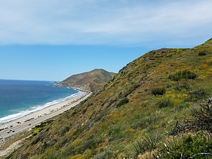
ocean view by SunDevil3  A loop formed by taking the Fire Road to the Fireline Trail to the Overlook Trail to the Scenic Trail from the Sycamore Canyon trailhead in Point Mugu State Park. Hike The fire road section is flat with a gentle grade (probably because it is a fire road) for approx 0.8 mi before the Fireline Trail splits off to the left. Fireline follows a number of switchbacks ascending the hills and passes through some very tall grass and --depending upon the season-- a wide array of wildflowers. The final stretch of Fireline is fairly steep leading up to a hilltop with a picnic table at the 2.1 mi intersection of the Overlook trail.
The ocean is in view in the distance for a good stretch of the trip back to the Fire Road. Slightly before Scenic rejoins the Fire Road, there are a number of small side trails that meander off into the bluffs overlooking the ocean. The Scenic trail dead-ends back into the Fire Road just beyond the trailhead.
Check out the Official Route and Triplogs. Leave No Trace and +Add a Triplog after your hike to support this local community. | ||||||||||||||||||||||||||||||||||||||||||||||||||||||||||||||||||||||||||||||||||||||||||