Overview
A short spur trail to a peak just off the Skyline Crest trail.
Getting There
From the main parking area, take Quartz Mine Trail approx 1.55 miles to the Skyline Crest Trail. Turn left on Skyline Crest and head up several switchbacks to the junction with Crest Summit Trail. At this point, you will have hiked approx 1.85 miles (575' aeg) from the trailhead to the beginning of Crest Summit Trail.
Hike
The hike to the summit is very straightforward. The trail is easy to follow, and takes a ridge up to the summit, making some short zigzags along the way. At 2100', this summit is the lowest of the four summit trails in the park. There are nice views in all directions, and you can see the parking area below you directly to the west.
Head back down the way you came. Once back at the Skyline Crest Trail, you can head south to retrace your steps to the trailhead or head north to complete Skyline Crest and loop around to the trailhead on one of the numerous other trails in the park.
When hiking several trails on a single "hike", log it with a generic name that describes the hike. Then link the trails traveled, check out the example.
WARNING! Hiking and outdoor related sports can be dangerous. Be responsible and prepare for the trip. Study the area you are entering and plan accordingly. Dress for the current and unexpected weather changes. Take plenty of water. Never go alone. Make an itinerary with your plan(s), route(s), destination(s) and expected return time. Give your itinerary to trusted family and/or friends.
Permit $$
None
Directions
Road
Paved - Car Okay
To Skyline Park Trailhead From Phoenix, take I-10 west to Watson Rd. Exit, and go north on Watson. Take Watson north approx 2 miles into the park.
The Entrance Lot is immediately after the gate where Watson turns 90 degrees west(left)
About 10-12 cars slot park on dirt just off the edge of the road.
- Parking Lot Connector Trail
- mid access to Quartz Trail
The developed Discovery Point Lot is 0.3 miles further in on Watson.
I'm not 100% sure on that name, needs verified. It's an obvious half moon oval.
- mid access to Parking Lot Connector Trail
The Main Lot is another 0.3 miles at the end of the road.
- all else, the majority
Park entry is FREE! Trails open sunrise to sunset. Gates close at 10 p.m.
From PHX (I-10 & AZ-51) 36 min (34.9 miles) From TUC (Jct 1-10 & Grant) 2 h 3 min (142 miles) From FLG (Jct I-17 & I-40) 2 h 22 min (159 miles)
 Route Editor

 Overview
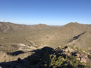


