 Route Editor

| Guide | ♦ | 1 Triplog | 0 Topics |
details | drive | no permit | forecast | route |
stats |
photos | triplog | topics | location |
| 13 | 1 | 0 |
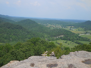
Long Time Getting Here by rvcarter  Carrington Rock is one of the few exposed crags in the Daniel Boone National Forest. I grew up looking at it from far away, or at least I thought it was far away at the time (under 10 air miles). Neither is it very high, by western standards, at 1380 feet asl. It is situated squarely on the border between Bath and Menifee Counties southeast of the Carrington Greens Golf Course and about half mile east of U.S. Hwy 36. Despite these modest statistics, Carrington Rock is iconic in this region simply because it’s exposed limestone rock is so unique in an area characterized by rolling hills whose vistas are mainly farms and forests. Haunted? “Images of Confederate Soldiers have been seen on and around this very high sandstone rock formation, it has been said, this was once a lookout post during the civil war. Also, there have been several sightings of a woman who paces around on top for a few minutes, and then plunges herself over the edge. Her screams, as she falls, can be heard up to a mile away. The forest and surrounding hollows in this area have produced sounds or orders coming from soldiers on the battle field, moans, cries of agonizing pain, and sightings of both confederate and union soldiers. Carrington Greens Golf Course has had reports from several of their customers about weird noises and seeing soldiers on the course, which is located on most of the battle field.” I found this on the internet, so it must be true.
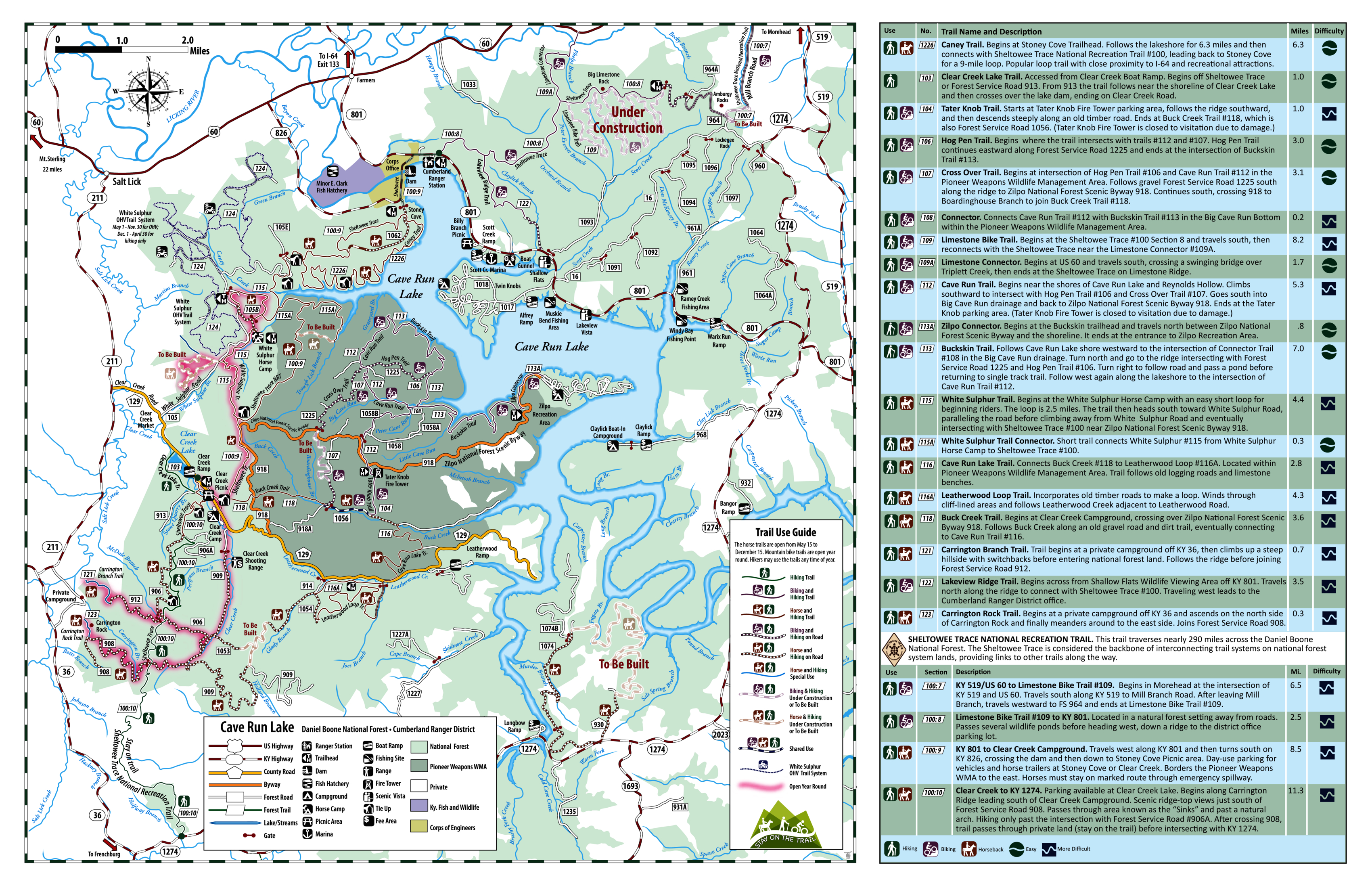
The hike is out and back on a trail wide enough for off-road vehicles, which are prohibited. You will share the trail with horses. The internet has lots of information about Carrington Rock, but some of it is erroneous, or involves trails to locations where one can SEE the rock, not get on top of it. One of the web sites I subscribe to described a trail that starts at a campground on Clear Creek Road (and uses part of the outstanding 319-mile Sheltowee Trace Nat. Rec. Trail that runs N/S through most of the Daniel Boone National Forest in KY and TN) gets you nowhere near the crag (believe me, I tried it on my first attempt). Once you reach the end of the track posted there, Carrington Rock is still 1.7 air miles to the SW. The beginning of the track suggests leaving from the campground (which involves a half mile slug fest across a creek and lots of poison ivy) when there is a nice clear trail from the Clear Creek Picnic Area just back down the road. So, it was misleading on two counts. Note: the Sheltowee Trace does not pass by Carrington Rock but may connect via a spur marked as Forest Road 908. See map. Be aware that the Carrington Rock Trailhead is not marked, at all. Had it not been for a blog I found on the internet, which shows a Google Earth screen grab and some good pix, I probably would not have found it, despite knowing exactly where the crag is located. Having a trail is nice since off trail in eastern Kentucky involves a lot of unknowns in summer (ticks, snakes, and the aforementioned poison ivy) and few landmarks (which you can’t see anyway because of the dense forest). Finding the Carrington Rock Trailhead is an adventure, but finding a parking spot might be equally difficult. The Carrington Green Road, which passes by the trailhead is in a residential area on a golf course. There is no place to park on the road (even if there was, beware of errant golf shots). However, there is a ball field about 0.3 mile further around with no “No Parking” signs and little activity most days. I’ve included a picture which shows where the ball field is. Hike Since this is eastern Kentucky, expect the trail to be muddy many days of the year. The horses probably keep it churned up most of the summer. The trail passes along and behind a residential property, then switchbacks up the hill to the crag. Watch at a few places where the trail up intersects other trails. These are not marked. Just stay on what seems to be the main trail. You eventually reach a place where the trail forks, take the steep but short slope up to the left. At the top of this part, there is a cabin with a small facade that seems out of place, but is a good trail marker. You can now see the looming cliffs a hundred feet or so through the trees. Pass by the cabin and proceed along the left (NNE) side of the crag on a well-used track. Wind around and through the openings in the underbrush until you come to a short rock chute equipped with a knotted rope (which is very useful in wet weather). Pull yourself up and continue on the trail until reaching another steep section that has a heavy duty plastic covered wire for assistance in scrambling to the top. Once on top, follow the trail until it splits, take the right path and follow it to the exposed outcropping, now only a couple hundred feet away. Very close to the outcropping, there are 2 or 3 places where scrambling is required; long legs are a blessing at these points. Since I was alone, I didn’t drop over to the lower part of the outcropping, even though getting back up didn’t seem all that difficult. This is where you’ll want to spend some time. The views for a crag only ~1,400 feet asl are magnificent. The green valleys and lush forests in every direction are quintessential Kentucky. Even though the humidity limits distance viewing, one can see the water towers in Owingsville, the capitol seat of Bath County. I could not see my nephew’s house, from whose back deck I can easily see Carrington Rock, a mere 10 miles away.
Check out the Official Route and Triplog. Leave No Trace and +Add a Triplog after your hike to support this local community. | ||||||||||||||||||||||||||||||||||||||||||||||||||||||||||||||||||||||||||||||||||||||||||||


