Route Editor

| Guide | ♦ | 4 Triplogs | 0 Topics |
details | drive | no permit | forecast | 🔥 route |
stats |
photos | triplogs | topics | location |
| 25 | 4 | 0 |
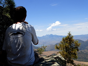
You can see for miles & miles & miles ... by kingsnake   The summit of Tanner Peak is less than a mile from the summit of Armer Mountain. You could do both in one hike, but it would add 1000 AEG of bushwhacking to your day. 1000 AEG on a trail is not so bad, but bushwhacking it makes much harder, slower & physical. Going up & down a trail is legs & lungs, but doing it through brush and over rocks is a full-body workout, likely involving plasma loss. The summit of Tanner Peak is less than a mile from the summit of Armer Mountain. You could do both in one hike, but it would add 1000 AEG of bushwhacking to your day. 1000 AEG on a trail is not so bad, but bushwhacking it makes much harder, slower & physical. Going up & down a trail is legs & lungs, but doing it through brush and over rocks is a full-body workout, likely involving plasma loss.I don’t know what the northwest slope of Armer Mountain is like, but I do know the wash up from Sawmill Flats Campground is full of razor blades, so if I was to do both Tanner Peak and Armer Mountain, I try it instead from the Rose Creek Campground. At least most of the mileage would be on an old jeep trail.
FR-95 is level for about 0.75 miles, before dipping about 200 ft. to some access roads to private property, on which I saw several barns/hunting cabins. At 1.5 miles, FR-95 turns west, away from the private property, and begins switchbacking uphill, about 800 ft. in a mile and a half. Halfway up the climb, on the right-hand side of the trail is an abandoned truck, in pretty good condition as such things go. FR-95 levels out for the next 1.5 miles until it begins climbing up the Deer Creek drainage, along the east slope of Tanner Peak. You could turn west at any time, and take Tanner Peak head-on, but it will be even steeper, rockier, and more tangled than the route I took. About 5.5 miles up FR-95, it reaches a saddle between Tanner Peak and Armer Mountain. If you were to double summit, this would be where you start ascending Armer. Just before the saddle, turn right, and head up the spine of Tanner Peak. It’s only a quarter-mile to the summit, but it is a steep, tangled, rocky, 300 ft. climb. It’s not nearly as bad as coming at it from the side: I’d know, since that is the way I started down, until thinking the wiser of it. Check out the Official Route and Triplogs. Leave No Trace and +Add a Triplog after your hike to support this local community. | |||||||||||||||||||||||||||||||||||||||||||||||||||||||||||||||||||||||||||||||||||||||||||||||