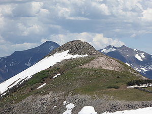
Blake and I and our friends, Joe and Paula, set out to hike the Continental Divide Trail (CDT) up to Alberta Peak on a beautiful, sunny day. We understood that there was a way to get onto the trail from the nearby ski area, but couldn't find the trailhead or an appropriate parking spot there. Instead, we drove past the ski area (headed west on 160 towards Pagosa Springs) and parked at Wolf Creek Pass. The CDT goes right through the pass and is a popular stopping point for tourists. The hike started out a bit congested (a bus had just let loose a boy scout troop), but the crowd quickly thinned out to just the four of us within minutes. The trail itself was muddy at the very beginning due to snow melt, probably for a 100 yards. Once we got to the edge of the forest, though, the moderately steep trail alternated between snow and a dirt path. Note that I rated the route finding a "2" because of the snow. Until we got into a clearing (which was actually one of the ski runs) we had to negotiate numerous fallen trees, none of which were very difficult to climb over. We stopped outside a ski hut for lunch and enjoyed the views and chance to catch our breath. Although the hike wasn't long or very steep, the altitude really got our attention! We continued along the ridgeline and were thrilled to see a fox frolicking among the rocks and in the snow below us. What a treat! We continued to a third ski hut and stopped for another break. We could easily see Alberta Peak (to the south), but we had run out of time due to a late start. Oh well, another day.....
WARNING! Hiking and outdoor related sports can be dangerous. Be responsible and prepare for the trip. Study the area you are entering and plan accordingly. Dress for the current and unexpected weather changes. Take plenty of water. Never go alone. Make an itinerary with your plan(s), route(s), destination(s) and expected return time. Give your itinerary to trusted family and/or friends.
Permit $$
FS
Directions
Road
Paved - Car Okay
To hike From South Fork, CO, drive west on 160 for 19 miles. Ample parking is found on either side of Wolf Creek Pass.
 Route Editor