Route Editor

| Guide | ♦ | 25 Triplogs | 0 Topics |
details | drive | permit | forecast | route |
stats |
photos | triplogs | topics | location |
| 86 | 25 | 0 |
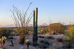
Need for Speed by mt98dew  Prologue PrologueOne of three routes within the McDowell Competitive Track. Technical, Sport & Long Routes Overview Fountain Hills Technical Loop. This is one of several Maricopa County Parks that have a collection of competitive tracks. (The other two being the White Tanks and the Estrella). In each case, they have four types of courses: beginner, short (or in the case of Fountain Hills Sport loop), technical, and a long loop. A noted difference to the Fountain Hills competitive track is that they have named features along the trail. For instance, the Technical Loop has "The Ledge", "T Bone Ridge", "the Chunnel", "Dan's Delight", and "The Bowl". All these trails are designated for "high speeds"...ideally for biking and running. Also, all tracks are designed to be done in one direction. Signs along the trail will help reinforce which direction one should be going.
Hike The start for the Technical loop occurs on the west end of the lot and is marked by a large brown sign. At the start, the trail almost immediately drops steeply into a wash. One might assume that this is "The Ledge". You'd be wrong. Very shortly after that (about 0.14 miles) the trail has another steep drop. This one is even more precipitous! Luckily, there is a side track that circles this feature for the sane. The trail then does some gradual climbing for a short distance as it reaches T Bone Ridge. The elevation change is a little more than 150 ft and is the most that you'll experience on this trail. The views are decent, though more limited to the east, due to the surrounding terrain. The trail stays on the ridgeline for a short time before dropping down to the west of the hill. At about 1.11 miles you reach "The Chunnel". This is a giant metal culvert that takes you under the Sport Loop. From here the trail turns south and has a nice little stretch where it remains straight and flat. You are a little higher up than the surrounding terrain so this gives you a chance to take in the nearby surrounding scenery. At 1.56 miles the trail starts to bend toward the east as it swings around T Bone Ridge. As it does this, the trail will twist and turn as it navigates around and over low-lying hills. I can see this being one of the more enjoyable segments for bikers. At 1.99 you reach Dan's Delight. Most signage corresponds to obvious features, not so much with Dan's Delight. I can only presume that Dan was a botanist and appreciated the flora in this unassuming low-lying trail section. There is a short climb as the trail leaves Dan's Delight and turns to the north. At this point, there is an option to take a designated side trail to connect to the Long Loop. Shortly after this juncture, one is treated with a view of "The Bowl" and the TH just beyond. The trail drops sharply into this open-ended valley and then does a gradual climb out the other side to arrive at the TH 2.72 miles later.
Check out the Official Route and Triplogs. Leave No Trace and +Add a Triplog after your mountain bike ride to support this local community. | ||||||||||||||||||||||||||||||||||||||||||||||||||||||||||||||||||||||||||||||||||||||||||||||||||||||||||||||||||||||||||||||||||||||||||||||||||||||||||||||||||||||||||||||||