 Route Editor

| Guide | ♦ | 10 Triplogs | 0 Topics |
details | drive | no permit | forecast | 🔥 route |
stats |
photos | triplogs | topics | location |
| 108 | 10 | 0 |
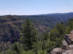
fine views by adenium   Overview OverviewWhite Horse Lake Campground is a nice little spot in the Kaibab National Forest and affords easy access to recreation around the upper Sycamore Canyon drainage. Two trails provide family-friendly hiking in the immediate area around the campground. These are the White Horse Lake Loop #33 and this trail, a spur off the White Horse Lake Loop. The suggested starting point for this hike is the north side of the loop, where plenty of parking is available. Hike Starting on the White Horse Loop, you will have a view across White Horse Lake. Soon the trail turns north into the ponderosa pine forest. Within half a mile of starting on the White Horse Loop, you will arrive at the trail junction with the Canyon Overlook Trail. From here, the trail dips down into a drainage that you'll see again at the end of the trail, and then The trail is reasonably level with only a couple of real ups and downs. A few deadfalls exist along the route, but nothing that presents a real challenge.
Check out the Official Route and Triplogs. Leave No Trace and +Add a Triplog after your hike to support this local community. One-Way Notice This hike is listed as One-Way. When hiking several trails on a single "hike", log it with a generic name that describes the hike. Then link the trails traveled, check out the example. | |||||||||||||||||||||||||||||||||||||||||||||||||||||||||||||||||||||||||||||||||||||||||||||||


