|
tap row or icons for details
|
| Distance One Way |
|
0 miles |
| Trailhead Elevation |
|
0 feet |
| Interest Off-Trail Hiking & Peak | | unreported if dogs are allowed
editedit > ops > dogs to adjust |
| | |
|
|
18 |
2017-07-10 |
The Carthew - Alderson Trail |
FOTG |
|
|
| |
|
|
list |
map |
done |
Alberta Region |
| | |
|
| |
|
|
Historical Weather |
| Trailhead Forecast | | |
|
 |
|
|
| Preferred Sep, Jun, May, Oct |
|
|
| | |
| |
Named Locations Coordinate Links
| |
|
| help future hikers |
| post a gps route now |
| The Carthew - Alderson Trail
|
14.76 mi
4,211 ft |
|
|
| | |
| |
|
|
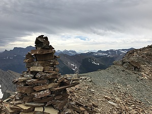
 Mount Alderson (8,832 feet, 2,692 m) is a barren, wind swept peak in Waterton Lakes National Park. The peak can be reached via a pretty straightforward off trail ridgeline route originating from the Carthew-Alderson Trail and more specifically the Carthew Lakes area. There is a well worn use trail to the peak, however, some class three scrambling may be necessary to negotiate some cliff bands along the distinct ridgeline.
One-Way NoticeThis hike is listed as One-Way. When hiking several trails on a single "hike", log it with a generic name that describes the hike. Then link the trails traveled, check out the example. |
 Route Editor


