Route Editor

| Guide | ♦ | 16 Triplogs | 0 Topics |
details | drive | no permit | forecast | map |
stats |
photos | triplogs | topics | location |
| 296 | 16 | 0 |
Canyons are inherently risky. Flash floods occur without notice on sunny days. Technical skills & surrounding topography knowledge required yet does not eliminate risk.
How bad could it be?? by ssk44   WARNING WARNINGThis destination was heavily damaged during the Mistake Peak Fire of 2012. Extreme runoff damage and fire scouring are present throughout the area. Check recent triplogs and photosets for current details. Overview Malicious Gap is a rugged canyoneering route in a remote region of the Sierra Ancha Mountains, within the Tonto National Forest. The hike is located near the Conway Ranch, just northeast of Greenback Valley. This location has been a local secret for years. Oops, not anymore! I found out about this route from a member of the Conway family that I periodically communicate with. He informed me that crazy hikers, as he called them, go up there every once in a while and somehow scramble their way through the rugged gap. I was immediately interested!
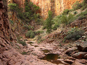
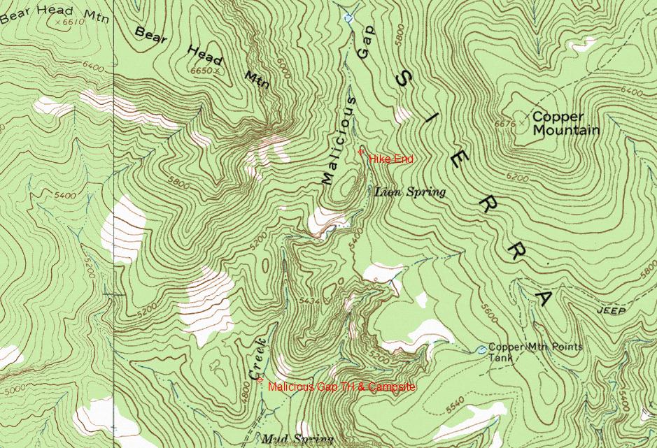
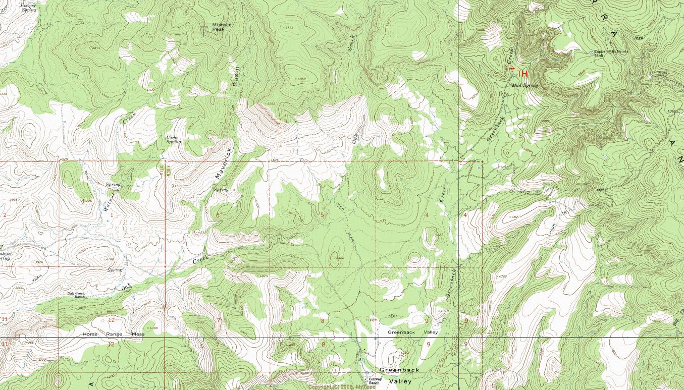
Hike With a name like "Malicious Gap", you can't help but be intrigued. It begs to be explored! The hike starts at the end of FR236A from a beautiful primitive campsite with extensive shade from large oak trees that line the lower Greenback Creek drainage. Just to the east of the campsite is Greenback Creek, which will be the route that you will be following. Route finding on this hike is a "no-brainer". This hike involves extensive boulder hopping and scrambling. Much of the canyon bottom is open with segments of solid bedrock. Bushwhacking is only moderate by my standards with about three particularly thick sections. What good off-trail backcountry hike doesn't have some bushwhacking to deal with? Not far into the hike, you will encounter the first of many gems along the route. I rounded a corner to find a monster, solid rock waterfall. Very cool!! I estimated it to be between forty and fifty feet high. That could be an exaggeration, but whatever it is, it's big and gnarly. Pictures don't do it justice. The initial part starts as a pour-over that quickly turned into a jagged and sheer overhanging rock face. Seeing this spot when Greenback Creek is running would be truly stunning. Greenback Creek typically runs in the winter months during snow runoff from warm periods between storms. Running water would add an interesting and possibly challenging variable to this hike and should be considered. I figured that this was the end of the line but noticed a faint trail from either game or people that headed up a steep slope just to the right through a grove of oak trees that climbed up about half the height of the waterfall. From that point, you could start to scramble up a section of small rock ledges heading back towards the middle of the canyon. The bypass is a fun scramble. However, the trail that follows the cliff ledges heading up to the top is very narrow and steep with small loose rocks lying on the ledges. This is not a section to be taken lightly. One poorly placed step and your hiking days are over. Beyond the main big waterfall, you will encounter numerous pour-overs and small waterfalls that can all be handled with manageable scrambling. The remaining sections of the hike are very fun with nothing too intimidating or dangerous. Not far up the canyon, there is one short section with a "trail bypass" that goes above a particularly thick section. I built a moderate-sized cairn just above the canyon bottom on the left side to mark the bypass. I did not notice any recent evidence of people heading up the canyon. No one has been through this canyon for some time. All of the trail sections looked to be primarily used by whitetail deer. Whitetail deer trails are a real pain for people to follow because they duck down real low and go under the brush rather than directly through it. I beat open a decent fresh path through the thick sections of the canyon with my walking staff to make things a little easier for future visitors to follow. Nearing the end of the hike you will pass "Lion Spring". The actual location of Lion Spring is difficult to determine. There was not the typically obvious spring location with large and thick trees. However, the water in the canyon bottom was particularly clear and healthy at one point with more current than most parts. The end of the hike as posted is very distinguishable (Lat. 33 degrees/55'/25.59"/N & Long. 111 degrees/6'/39.51"/W). While walking up from the Lion Spring segment you will eventually encounter a very tall sheer rock face with a dry waterfall on the right side. Work your way around the left side of the rock face through a steep section of oak trees to come out onto a nice flat open area on top with a few nice ponderosa pines around for shade. This seemed like a good ending point for this great hike. Just prior to the posted end for the hike was a perfect small backpacking campsite just off the trail with lots of shade from big oak trees. A short walk down towards Lion Spring would provide plenty of good water. See attached map for the location of the GPS waypoint described in the text. Summary Malicious Gap is truly a great scramble hike with awesome scenery and lots of interesting places to explore. Nice and short, and not overwhelmingly difficult. Very rewarding and fun hike! Seeing this beautiful canyon with a swift stream running down it would be off the chart! Truly special destination. Count on having it all to yourself if you go.
Check out the Triplogs. Leave No Trace and +Add a Triplog after your canyon trip to support this local community. | ||||||||||||||||||||||||||||||||||||||||||||||||||||||||||||||||||||||||||||||||||||||||||||||||||||