Route Editor

| Guide | ♦ | 18 Triplogs | 0 Topics |
details | drive | no permit | forecast | route |
stats |
photos | triplogs | topics | location |
| 260 | 18 | 0 |
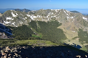
New Mexico's Tallest! by imike The trail climbs steeply with numerous offshoots. Simply stay on the widest path and do not go off on any of the trails marked for horses. You move up drainage adjacent to a stream that may be simply a trickle or a nice torrent. In the first miles you will do your one and only stream crossing. On the trail there may be some nice logs to walk across, if needed, but usually 20yds upstream there may be an easier log crossing if your balancing skills are not so great.
You will move up and up until finally cresting on the ridge, which you will follow for the remainder of the hike. If there is no snow obscuring the trail, the path is simple and well worn. If there is snow, then depending on the amount, the path may well be yours to choose. If you are properly outfitted, traversing the snow covered areas will not present any major problem. Or, if you do the hike like we did, taking no snow equipment whatsoever, then you are in for a potentially too interesting day. Skis or snowshoes are in order, even as late as through May. Without those aids it is easy to spend the day trudging through knee to crotch high snow, with a number of deeper plunges to make the trek an ever higher quality exercise experience. In mid May 2009 we found ourselves in snow from the first mile up until the final high miles (where we could finally avoid most of the snow covered ground by walking the edge of the sunny-side ridges). Eventually, the trail moves through a high, broad basin as it begins the soft switchbacks to the ridge and the approach to Mount Walker. You do get to summit two very high peaks, in fact Mt Walker (13,141') is the second highest named peak in New Mexico, but because it only has about 100 feet of prominence it is not really considered an independent peak by most. Once at Walker, you descend a bit, then walk the ridge the final distance over to Wheeler. Expect anything at this elevation. Count on wind. Come prepared. If the trail is snow covered, plan on 8 to 10 hours of effort for the up/down hike if you are in good shape. Some people use that much time without snow. It is not uncommon to backpack in and split the effort in half. There are a number of great csmping options to consider, the ridge area beyond and above Bull of the Woods meadow being what might be the nicest. Above that you begin to leave the tree line and enter very exposed sections. Wheeler Peak: named after George M. Wheeler... Army Major noted for survey of area. There is a shorter route for reaching the peak: via Williams Lake, which includes a final approach strait up the side of the mountain over loose talus... not fun, but challenging. Too much snow prevented our engaging that route this trip; saved for another day. In the summer months, when the likelihood of not having to address too much snow is better, you become subject to the monsoon patterns... best to get a very early start and be off the mountain midday, to avoid the potential for thunderstorms in the afternoon. Lightening is a very real danger up there. Lots more that could be said, but... Check out the Official Route and Triplogs. Note This is a moderately difficult hike. Leave No Trace and +Add a Triplog after your hike to support this local community. | |||||||||||||||||||||||||||||||||||||||||||||||||||||||||||||||||||||||||||||||||||||||||||||||||||