 Route Editor

| Guide | ♦ | 1 Triplog | 0 Topics |
details | drive | no permit | forecast | route |
stats |
photos | triplog | topics | location |
| 3 | 1 | 0 |
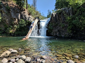
Step up and jump by lojones5  Hatchet Creek Falls is not only a gorgeous waterfall, but a perfect place to cool down in the summer and swim in a deep pool below the falls. For adrenaline seekers there are a couple spots to cliff jump from height around the falls, and for those not quite ready for that there is a large tree trunk with steps carved out that can be climbed and jumped off of from whatever height is comfortable. The spot is fairly well known, but does not have nearly as many visitors as McCloud Falls. Warning Watch for poison oak and be careful walking/climbing slippery surfaces. Always check water depth and obstacles if jumping from heights.
The hike itself is extremely short and begins at the end of the parking turnoff. There appear to be two paths fro the parking area and I recommend taking the path on the right. This path follows under some overgrown brush and shortly reaches the creek. You can now follow the path hugging the right side of the creek, you may have to step in the water at some points. There may be an alternative path to the right of the creek, but I was told the creek path is easiest. You will hear the falls immediately and see them very soon after beginning to follow the creek. Water Sources Hatchet Creek Check out the Official Route and Triplog. Leave No Trace and +Add a Triplog after your hike to support this local community. One-Way Notice This hike is listed as One-Way. When hiking several trails on a single "hike", log it with a generic name that describes the hike. Then link the trails traveled, check out the example. | ||||||||||||||||||||||||||||||||||||||||||||||||||||||||||||||||||||||||||||||||||


