This is likely a great time to hike this trail!  Check out "Preferred" months below, keep in mind this is an estimate.
  🔥

JD Dam, AZ

Guide 4 Triplogs Mine 0 0 Topics
 
4 of 5 
Fav
Wish
0
details
drive
no permit
forecast
🔥
route  
stats
photos
triplogs
topics
location
23 4 0
Statistics
tap icons for details
Difficulty 0.5 of 5
Distance Loop 1.21 miles
Trailhead Elevation 6,459 feet
Elevation Gain 3 feet
Accumulated Gain 7 feet
Avg Time One Way 30-60 min
Kokopelli Seeds 1.23
 Interest Off-Trail Hiking
feature photo
Photos Viewed All MineFollowing
Will recalculate on button tap!
17  2017-08-29 Oregon_Hiker
6  2017-08-11 chumley
45  2017-08-10
Summer HAZFest 2017
outdoor_lover
Author
author avatar Guides 16,883
Routes 17,294
Photos 24
Trips 1 map ( 6 miles )
Age 26 Male Gender
Location HAZ, TrailDEX
Associated Areas
list map done
Prescott Region
Historical Weather
Trailhead Forecast
Radar Map
Expand Map
Preferred May, Oct, Sep, Apr
Sun  5:20am - 7:30pm
Official Route
 
0 Alternative
 
 Water
Historic Fire Perimetersacres
🔥 2021 Raphael Fire68.5 mi**
🔥 2002 Trick25.8 mi*
🔥 View (All) - over Official Route 🔥
*perimeter length in miles
**possible voids inflate figure
Nearby Area Water
[ View More! ]
Fauna  Nearby
Culture  Nearby

 Likely In-Season!
Guide Needed
Publish Full Detail Guide


Use +Add above to share photos and triplogs
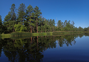
JD Dam is the jewel of the Williams district of the Kaibob national forest. It has a great number of birds to see. Fishing is catch and release only, with barbless hooks.

Check out the Official Route and Triplogs.


Leave No Trace and +Add a Triplog after your hike to support this local community.

2017-08-14

    One-Way Notice
    This hike is listed as One-Way.

    When hiking several trails on a single "hike", log it with a generic name that describes the hike. Then link the trails traveled, check out the example.
    WARNING! Hiking and outdoor related sports can be dangerous. Be responsible and prepare for the trip. Study the area you are entering and plan accordingly. Dress for the current and unexpected weather changes. Take plenty of water. Never go alone. Make an itinerary with your plan(s), route(s), destination(s) and expected return time. Give your itinerary to trusted family and/or friends.

     Permit $$
    None


     Directions
    or
    or
     Road
    FR / Dirt Road / Gravel - Car Okay

    To hike
    From White Horse Lake, take FR12 southeast to Sycamore Point road, turn right and go 1 mile, then turn left into the parking area.

    Cars should be able to make it with some caution.
    page created by nonot on Aug 14 2017 4:50 pm
     90+° 8am - 6pm kills
    Avoid Heat Illness - stay cool
    helpcorrectionissue

    end of page marker