Route Editor

| Guide | ♦ | 2 Triplogs | 0 Topics |
details | drive | no permit | forecast | route |
stats |
photos | triplogs | topics | location |
| 113 | 2 | 0 |
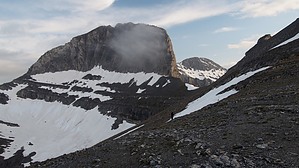
Zeus ain't got nothin' on this! by arizona_water The Olympus Massif is the highest point in Greece and has 52 peaks, deep gorges, and exceptional biodiversity. The highest peak Mytikas, meaning "nose", rises to 2,918 meters (9,573 ft). It is one of the highest peaks in Europe in terms of topographic prominence. Olympus was notable in Greek mythology as the home of the Greek gods, on the Mytikas peak. Mount Olympus is also noted for its rich biodiversity. In 1938, Olympus became the first national park established in Greece. It is also a World's Biosphere Reserve (UNESCO).
Note The final climb to the true summit (known as Mytikas) has many class IV moves. This should not be attempted without technical gear when ice, snow, or moisture are present. Hike This world class hike ascends through three environmental biomes through a network of trails. Many hikers choose to do the hike in two days and spend a night in a hiker's lodge on either the Plateau of Muses or on the south side of the massif. Trails are well marked and easy to follow until reaching the summit. With two main trailheads (Prionia and Gortsia), there are a few options for either out-and-back or one-way routes. Whichever route you choose, you will encounter several staffed hiker huts, or refuges. These are stocked by mule train and offer hot meals, cold beer, and bunk beds. The prices are much more affordable than their mountain refuge cousins to the north (aka Switzerland). Water Sources The hikers huts on the northeast side of the mountain of have surface water (other than snow), so all water resources must be packed. The huts are stocked by mules, so you could purchase water bottles from the staff, if needed. The hut on the southeast side does have running water that is unfiltered from glacial melt. In fact, the lower half of the southern trail to Prionia follows a beautiful glacial stream. Check out the Official Route and Triplogs. Note This is a more difficult hike. It would be unwise to attempt this without prior experience hiking. Leave No Trace and +Add a Triplog after your hike to support this local community. | ||||||||||||||||||||||||||||||||||||||||||||||||||||||||||||||||||||||||||||||||||||||||