 Route Editor

| Guide | ♦ | 4 Triplogs | 0 Topics |
details | drive | no permit | forecast | map |
stats |
photos | triplogs | topics | location |
| 32 | 4 | 0 |
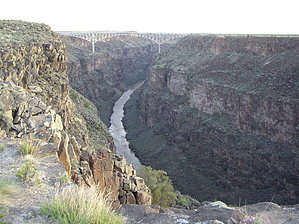
Fun in the Sun... by imike  Sitting there you may get to observe the rafters or kayakers drifting along far down in the bottom... or wonder about the impressive span bridge (I think the second highest in the USA?)... or if you're out early, see the crazy hot air balloons drifting over then down into the canyon below the rim! I thought they were in trouble then later read in some of their brochures that they offer that bit of excitement and drama as part of their normal ballooning experience. Wow.
Because of the exposed nature of the trail, it is definitely an early morning or later in the day type of trip. You are at 7,000' and the air is cooler, but the sun will rule on this trail. There is a nice restroom at the trailhead. It is worth the drive out from Taos to add these trail hours to your trip along this Rio Grand National Wild and Scenic River corridor. Check out the Triplogs. Leave No Trace and +Add a Triplog after your hike to support this local community. One-Way Notice This hike is listed as One-Way. When hiking several trails on a single "hike", log it with a generic name that describes the hike. Then link the trails traveled, check out the example. | |||||||||||||||||||||||||||||||||||||||||||||||||||||||||||||||||||||||||||||||||||


