username
X
password
register
for free!
help
 This is likely a great time to hike this trail!  Check out "Preferred" months below, keep in mind this is an estimate.
  

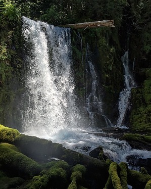
Upper Downing Creek Falls, OR

Guide 2 Triplogs  0 Topics
  5 of 5  
Fav
Wish
0
details
drive
permit
forecast
map
stats
photos
triplogs
topics
location
20 2 0
Statistics
tap row or icons for details
Difficulty 1 of 5
Distance Round Trip 0.7 miles
Trailhead Elevation 3,113 feet
Elevation Gain 164 feet
Kokopelli Seeds 1.52
 Interest Off-Trail Hiking, Perennial Waterfall & Perennial Creek
unreported if dogs are allowed
editedit > ops > dogs to adjust
feature photo
Photos Viewed All MineFollowing
15  2019-11-09 Lucyan
5  2017-07-02 arizona_water
Author
author avatar Guides 16,843
Routes 17,472
Photos 24
Trips 1 map ( 6 miles )
Age 28 Male Gender
Location HAZ, TrailDEX
Associated Areas
list map done
North Central Region
Historical Weather
Trailhead Forecast
Expand Map
Preferred Sep, Jul, Aug, Jun
Sun  5:35am - 6:37pm
1 Route
 
0 Alternative


remove free decal offer

 Likely In-Season!
Guide Needed
Publish Full Detail Guide


Use +Add above to share photos and triplogs
Follow a decommissioned logging road up to an obvious social-trail that descends to Downing Creek. Follow the north bank until you reach the falls.


    Check out the Triplogs.
    Leave No Trace and +Add a Triplog after your hike to support this local community.
    WARNING! Hiking and outdoor related sports can be dangerous. Be responsible and prepare for the trip. Study the area you are entering and plan accordingly. Dress for the current and unexpected weather changes. Take plenty of water. Never go alone. Make an itinerary with your plan(s), route(s), destination(s) and expected return time. Give your itinerary to trusted family and/or friends.

     Permit $$
    no fees or permits reported

    if incorrect tell us about it

    Willamette Forest
    more info


     Directions
    or
     Road
    FR / Dirt Road / Gravel - Car Okay

    To hike
    From Salem, take Oregon State Highway 22 south until you reach FR161. The turnoff is mostly hidden behind overgrown branches and the forest road is unmarked. Drive slow and look east for a dirt roading leading up the mountain.
    page created by arizona_water on Aug 28 2017 11:32 pm
     90+° 8am - 6pm kills
    helpcorrectionissue

    end of page marker