Route Editor

| Guide | ♦ | 1 Triplog | 0 Topics |
details | drive | no permit | forecast | map |
stats |
photos | triplog | topics | location |
| 16 | 1 | 0 |
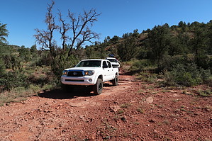
Cliffhanger by cw50must   This drive starts off Lower Red Rock Loop. It consists of following FR9845, then taking FR9845N to the locked gate, then turning around back to FR9845 and continuing on it out to 89A. There are a few campsites near 89A. This is an interesting drive that is suitable for high-clearance 4wd vehicles. I would consider it moderate, with one difficult section known as a "cliffhanger" on FR9845N which is a narrow shelf road that must be navigated down and then back up again. This drive starts off Lower Red Rock Loop. It consists of following FR9845, then taking FR9845N to the locked gate, then turning around back to FR9845 and continuing on it out to 89A. There are a few campsites near 89A. This is an interesting drive that is suitable for high-clearance 4wd vehicles. I would consider it moderate, with one difficult section known as a "cliffhanger" on FR9845N which is a narrow shelf road that must be navigated down and then back up again.There is a locked gate at the bottom of FR9845N, a short hike will take you down to Oak Creek and the remains of a stone cabin, a good place for a picnic. It's not the most scenic drive in Sedona, but it's still Sedona, so it has its moments. There usually is other traffic out here, and keep in mind this is a trail the Hummer Tour company uses so there will be tourists out there as well. At 5.7 miles it's somewhat short, but still, allow around 3 hours to complete. Gate Policy: If a gate is closed upon arrival, leave it closed after you go through. If it is open, leave it open. Leaving a closed gate open may put cattle in danger. Closing an open gate may cut them off from water. Please be respectful, leave gates as found. The exception is signage on the gate directing you otherwise.
Check out the Triplog. Leave No Trace and +Add a Triplog after your 4x4 trip to support this local community. | ||||||||||||||||||||||||||||||||||||||||||||||||||||||||||||||||||||