 Route Editor

| Guide | ♦ | 7 Triplogs | 1 Topic |
details | drive | no permit | forecast | 🔥 route |
stats |
photos | triplogs | topic | location |
| 16 | 7 | 1 |
No crackers, Jack! by kingsnake  Crackerbox Canyon most closely resembles its next-door neighbor, East Miller Canyon. (Crackerbox drains into East Miller and, eventually, East Clear Creek.) I’ve always found it odd that the Mogollon Rim mostly drains north, gradually downslope, rather than tumbling south, over the cliff, in spectacular waterfalls. The Mogollon Rim is the continental divide of Arizona. Crackerbox Canyon most closely resembles its next-door neighbor, East Miller Canyon. (Crackerbox drains into East Miller and, eventually, East Clear Creek.) I’ve always found it odd that the Mogollon Rim mostly drains north, gradually downslope, rather than tumbling south, over the cliff, in spectacular waterfalls. The Mogollon Rim is the continental divide of Arizona.The hike starts by heading back down FR 391 for a hundred yards to FR 141H, then east down FR 141H for not quite a half-mile. The low point in the road is Crackerbox Canyon.
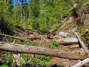
Once you are in Crackerbox Canyon, you follow it north for 4.7 miles to the intersection with East Miller Canyon. The first three miles in Crackerbox Canyon, to the barbwire fence, are very mellow travel. For me, the creek bed was totally dry. There are often shelves on either bank. There is minor deadfall here & there, but it is easily avoided by switching to the other bank or walking for a while in the creek bed. The first couple of miles would make a great introduction to canyon hiking for kids. If you do hike with kids or don’t relish low crawling, in the dirt, under large logs, there’s a good bailout point about 2.5 miles down Crackerbox Canyon, where there is a good size meadow of ferns and false hellebore on both the east and west bank of the wash. Head west, across the meadow, and uphill 100 ft. to FR 501, following that back to the trailhead. Crackerbox Canyon starts so mellow because it is shallow and its cross-section flat. The barbwire fence is easily crossed. North of the fence, Crackerbox gets deeper (about 200 ft.), narrower, with a steeper slope. North of the barbwire fence, Crackerbox Canyon is frequently choked with deadfall and boulders. There is running water or good size pools on rare breaks from crawling over or under an obstacle. You will not only get dirty, but wet as well. I wouldn’t want to be caught in there if there was a flash flood. The far end of the loop is where Crackerbox Canyon empties into East Miller Canyon. Head up the steep 200 ft. bluff to your left (south). At first, FR 501 was barely detectable. It was mostly grass. It was only after reaching the gateless barbwire fence — a continuation of the same fence down in Crackerbox Canyon — that I realized why FR 501 was so indistinct: It is being returned to nature. South of the fence, FR 501 was a typical jeep trail. From the top of the bluff, it is 4.3 flat, shady miles south on FR 501 to FR 141H, then only another .40 miles east to FR 391 and the trailhead. Gate Policy: If a gate is closed upon arrival, leave it closed after you go through. If it is open, leave it open. Leaving a closed gate open may put cattle in danger. Closing an open gate may cut them off from water. Please be respectful, leave gates as found. The exception is signage on the gate directing you otherwise. Check out the Official Route and Triplogs. Leave No Trace and +Add a Triplog after your hike to support this local community. One-Way Notice This hike is listed as One-Way. When hiking several trails on a single "hike", log it with a generic name that describes the hike. Then link the trails traveled, check out the example. | |||||||||||||||||||||||||||||||||||||||||||||||||||||||||||||||||||||||||||||||||||||||||||||||||||||||||||||||||||||||||||||||||||||||||||||||||||||||||||||||||||||||||||||||||||||||||||||||||||||||


