username
X
password
register
for free!
help
 This is likely a great time to hike this trail!  Check out "Preferred" months below, keep in mind this is an estimate. 
 

Mount Sunflower - Kansas High Point, KS

Guide 2 Triplogs  0 Topics
  4 of 5  
Fav
Wish
0
details
drive
no permit
forecast
map
stats
photos
triplogs
topics
location
14 2 0
Statistics
tap row or icons for details
Route Finding 1 of 5
Distance Round Trip 0.001 miles
Trailhead Elevation 4,037 feet
Avg Time Round Trip 30 seconds
 Interest Peak
 Backpack No
unreported if dogs are allowed
editedit > ops > dogs to adjust
feature photo
Photos Viewed All MineFollowing
10  2020-07-18 DixieFlyer
4  2017-10-18 Stoic
Author
author avatar Guides 99
Routes 1,484
Photos 16,072
Trips 1,374 map ( 13,602 miles )
Age Male Gender
Location Fountain Hills, AZ
Associated Areas
list map done
Northwest Region
Historical Weather
Trailhead Forecast
Expand Map
Preferred Jun, Jul, Aug, Sep
Seasons   Spring to Autumn
Sun  6:19am - 7:14pm
0 Route
 
0 Alternative


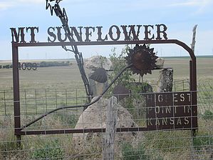
Ain't No Sunflower Higher
by DixieFlyer

 Likely In-Season! 
Overview
Mount Sunflower (elevation 4,039') is the high point in the state of Kansas. It is in far western Kansas, about 1/2 mile from the Colorado border.


History
Although Mount Sunflower is quite a distance from the Rocky Mountains, it still owes its lofty height to the Rockies. According to the Kansas Geological Survey, the High Plains upon which Mount Sunflower lies were built up from massive amounts of sand, gravel, and other rock debris worn off the Rockies and carried east by flowing streams millions of years ago. As streams deposited the sediment, it formed into a giant wedge called the Ogallala Formation, which is the foundation for the High Plains.
remove free decal offer
Hike
Mount Sunflower is not a peak or a summit, and some people would describe it as a barely noticeable rise in the middle of a field; however, those people would surely be lacking in vision!

This is not a hike, per se; instead, you just drive your vehicle up to Mount Sunflower and park next to the summit. The summit is on private land, and over the years the landowners have erected a small shrine for Mount Sunflower, including a covered picnic area, a metal sculpture, rocks, a mailbox which contains a guest register, and a memorial to Edward and Elizabeth Harold, who homesteaded the area in 1905.

The guest register includes an invitation to stop by the ranch house and tell "about your trials and tribulations to the lofty summit. Local guides are also available at the homestead for an outrageous fee."

More details on Mount Sunflower can be found on the Kansas Travel website.

Red Tape
Mount Sunflower is located on private land, although no permit or fee is needed. However, please treat the property as if it was your own; after all, that is the right thing to do!

2020-07-26 DixieFlyer


    Check out the Triplogs.
    Leave No Trace and +Add a Triplog after your hike to support this local community.
    WARNING! Hiking and outdoor related sports can be dangerous. Be responsible and prepare for the trip. Study the area you are entering and plan accordingly. Dress for the current and unexpected weather changes. Take plenty of water. Never go alone. Make an itinerary with your plan(s), route(s), destination(s) and expected return time. Give your itinerary to trusted family and/or friends.

     Permit $$
    None


     Directions
    or
     Road
    FR / Dirt Road / Gravel - Car Okay

    To hike
    There is no way to get to Mount Sunflower without driving at least 15 miles on dirt roads. However, the roads are well-graded and are suitable for almost any passenger vehicle, at least when dry. However, things might be different during periods of heavy rain or snow.

    To get there, you can search google maps for "Mount Sunflower", or go to these coordinates: 39.02196, -102.03719.

    The Kansas Travel website provides these directions:
    From US 40 take Road WA S-3 (3 miles west of Weskan, Kansas) north for 13 miles, turn west on the un-named road (there is a Mount Sunflower sign) just over 1 mile, then turn right (north) onto the ranch at the clearly marked Mount Sunflower entrance.

    From I-70, take Kansas Highway 27 south from Goodland for 17 miles, turn west on Road WA-W-BB for 12 miles, south on Road WA-N6 for 4 miles, west on WA-W-X Road for 3 miles, south on Road WA S-3 for one mile, west on the un-named road just over 1, then turn right (north) onto the ranch at the clearly marked Mount Sunflower entrance. Most, but not all, of the turns on the way to Mount Sunflower have signs.
    page created by Stoic on Jul 26 2020 6:39 am
     90+° 8am - 6pm kills
    helpcorrectionissue

    end of page marker