username
X
password
register
for free!
help
 
  🔥

Black Mountain - Eastern Superstition Mtns, AZ

Guide 3 Triplogs  0 Topics
  3 of 5  
Fav
Wish
0
details
drive
no permit
forecast
🔥
route  
stats
photos
triplogs
topics
location
16 3 0
HAZ reminds you to respect the ruins. Please read the Archaeological Resources Protection Act of 1979 & Ruins Etiquette
Statistics
tap row or icons for details
Difficulty 4 of 5
Route Finding 2 of 5
Distance Loop 7.15 miles
Trailhead Elevation 3,216 feet
Elevation Gain 1,887 feet
Accumulated Gain 3,000 feet
Kokopelli Seeds 22.15
 Interest Ruins & Peak
feature photo
Photos Viewed All MineFollowing
5  2022-02-06 pseudalpine
6  2017-11-25 FOTG
5  2017-11-25 wallyfrack
Author
author avatar Guides 16,843
Routes 17,472
Photos 24
Trips 1 map ( 6 miles )
Age 28 Male Gender
Location HAZ, TrailDEX
Co-Author
co-author avatarGuides 37
Routes 556
Photos 10,872
Trips 1,052 map (10,600 Miles)
Age 43 Male Gender
Location AZ
Associated Areas
list map done
Globe Region
Historical Weather
Trailhead Forecast
Radar Map
Expand Map
Preferred Apr, Oct, Mar, Nov → 7 AM
Sun  6:00am - 6:46pm
Official Route & 1 Rt
 
0 Alternative
 
Historic Fire Perimeteracres
🔥 2019 Woodbury Fire123.8k


remove free decal offer

 
Guide Needed
Publish Full Detail Guide


Use +Add above to share photos and triplogs
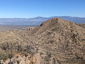
Black Mountain is an indiscriminate peak located just outside the boundary of the Eastern Superstition Mountains. The summit can most easily be reached from an off trail approach leaving from the Campaign Creek Trailhead. There is not likely to be any water along this route and the ability to travel and navigate off trail is needed to reach the summit.


    Check out the Official Route and Triplogs.

    Note
    This is a moderately difficult hike.
    Leave No Trace and +Add a Triplog after your hike to support this local community.
    WARNING! Hiking and outdoor related sports can be dangerous. Be responsible and prepare for the trip. Study the area you are entering and plan accordingly. Dress for the current and unexpected weather changes. Take plenty of water. Never go alone. Make an itinerary with your plan(s), route(s), destination(s) and expected return time. Give your itinerary to trusted family and/or friends.

     Permit $$
    no fees or permits reported

    if incorrect tell us about it


     Directions
    or
     Road
    Paved - Car Okay

    To hike
    page created by FOTG on Nov 25 2017 5:11 pm
     90+° 8am - 6pm kills
    helpcorrectionissue

    end of page marker