username
X
password
register
for free!
help
  

Cinco Tinajas - Big Bend Ranch State Park, TX

Guide 0 Triplogs  0 Topics
  0 of 5  
Fav
Wish
0
details
drive
permit
forecast
route  
stats
photos
triplogs
topics
location
12 0 0
Statistics
tap row or icons for details
Difficulty 1 of 5
Route Finding 1 of 5
Distance Lasso-Loop 1.25 miles
Trailhead Elevation 4,088 feet
Elevation Gain 60 feet
Accumulated Gain 143 feet
Kokopelli Seeds 1.97
 Interest Historic
 Backpack TBD
unreported if dogs are allowed
editedit > ops > dogs to adjust
feature photo
Photos Viewed All MineFollowing
12  2017-11-19 Steph_and_Blake
Author
author avatar Guides 100
Routes 63
Photos 2,548
Trips 184 map ( 820 miles )
Age 76 Male Gender
Location Grand Junction, CO
Associated Areas
list map done
Big Bend Region
Historical Weather
Trailhead Forecast
Radar Map
Expand Map
Preferred Feb, Nov, Dec, Jan
Sun  6:35am - 7:13pm
Official Route
 
0 Alternative


Overview
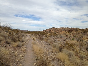
A short, easy hike to view five tinajas (Spanish for water-filled basins), a rarity in such an arid environment. These pools, which contain water nearly year-round, are important for many different plants and animals and have supported people throughout history.


The Hike
The hike begins at the trailhead located about a mile and a half west of the Sauceda visitor center, on the north side of the Main Road. A gradual rise to the north takes you to a decision point. Turning right (east) leads you up a small incline to an overview of the five pools. Otherwise, continue north/downhill to the creek. Upon reaching the creek take a right up the wash. Follow the wash until you reach the bottom pool.
remove free decal offer
On our outing we first went to the bottom pools, then back-tracked to the "decision point". From there we took a left (headed east) to see the upper pools from the overlook. From there we back-tracked about half-way to the "decision point" and then took a hard left and went in a southeast direction to arrive beside the top pool. From there we followed the wash (that leads to the pools) back to the parking area. Along the way back to the vehicle there are stone and cement walls and dams that previous ranchers had built.

While not a spectacular hike, it's a good place to have a quick stretch of the legs after driving hours (and hours!) to the park. It would also be a fun place to let youngsters explore (note that swimming is not allowed). I should also note that you can combine this hike with the Leyva Escondido Loop Trail. The Leyva trail, so the brochure says, is moderate-to-difficult due to deep sand and steep climbs. However, the Leyva trail takes you past an archaeological site with prehistoric pictographs.

2017-11-30 Steph_and_Blake


    Check out the Official Route.
    Leave No Trace and +Add a Triplog after your hike to support this local community.
    WARNING! Hiking and outdoor related sports can be dangerous. Be responsible and prepare for the trip. Study the area you are entering and plan accordingly. Dress for the current and unexpected weather changes. Take plenty of water. Never go alone. Make an itinerary with your plan(s), route(s), destination(s) and expected return time. Give your itinerary to trusted family and/or friends.

     Permit $$
    Fees are typically $4-$7 per person. Check the texas.gov site for park hours and current fees.


     Directions
    or
     Road
    FR / Dirt Road / Gravel - Car Okay

    To hike
    From Marfa, TX, take 67 south to Presidio. Then get on FM 170 southeast, headed toward Lajitas. Pass the Fort Leaton historical site (on your right). ~3 miles past the Fort take a left onto Casa Piedra road. Follow the signs to the Sauceda visitors center (27 miles from FM 170). At mile 25 keep an eye out for a small parking area on your left. If you miss it and reach the visitor center, just turn around and go back for 1.3 miles.
    page created by Steph_and_Blake on Nov 30 2017 3:43 pm
     90+° 8am - 6pm kills
    helpcorrectionissue

    end of page marker