 Route Editor

| Guide | ♦ | 3 Triplogs | 0 Topics |
details | drive | no permit | forecast | route |
stats |
photos | triplogs | topics | location |
| 15 | 3 | 0 |
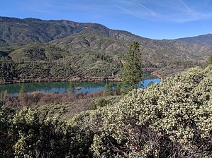
Single Track to Shasta Dam by lojones5  The Upper Sacramento Ditch trail is a nicely smooth and fairly level trail that extends about 9 miles from Walker Mine Rd Trailhead up to Shasta Dam. The trail is nicely isolated from the city so it remains relaxing and very quiet. There are several fantastic views of the Sacramento River, and near the Northern end of the trail there are great views of Shasta Dam with Mt. Shasta poking above in the background. At the North end of the trail you can take a break at a nice picnic area by the dam with awesome views of Shasta Lake. The picnic areas are well kept with gorgeous green grass year long. Warning The area around Shasta Dam is a government facility, be sure to stay on the main trail to avoid trespassing.
The Sacramento Ditch once brought water to early miners during the gold rush era. During the construction of Shasta Dam, a conveyor belt passed along this trail to supply gravel all the way from near the Turtle Bay/Sundial Bridge area up to the location of Shasta Dam. Look out for rounded stream cobbles as evidence of this conveyor belt. Hike The trail is popular for both hikers and bikers, it is a very smooth single track trail with little to no elevation change. There are plenty of benches along the way for resting, and for viewing scenic points along the trail. There is a large impressive looking acorn tree a couple miles from Walker Mine Rd. trailhead near the southern side of the trail that has a full picnic bench. Near the North end of the trail, there are three foot bridges where you may see some small waterfalls during the spring.
Check out the Official Route and Triplogs. Leave No Trace and +Add a Triplog after your hike to support this local community. One-Way Notice This hike is listed as One-Way. When hiking several trails on a single "hike", log it with a generic name that describes the hike. Then link the trails traveled, check out the example. | ||||||||||||||||||||||||||||||||||||||||||||||||||||||||||||||||||||||||||||||||||


