 Route Editor

| Guide | ♦ | 44 Triplogs | 0 Topics |
details | drive | permit | forecast | route |
stats |
photos | triplogs | topics | location |
| 127 | 44 | 0 |
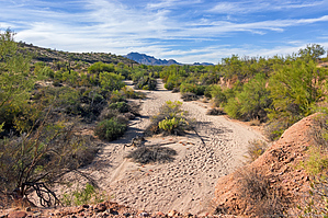
scrub a dub dub by KBKB  Overview OverviewThe Shallmo Wash Trail is located in McDowell Mountain Regional Park. At its southeast end, it is accessed from the Four Peaks / Horse Staging Area. This is a gravel/dirt parking lot that may be accessed via the first driveway to the right encountered after passing the Park's entry station. The start of the trail is found at the northwest corner of the parking lot.
Despite its name, it is a hard-packed trail, not a wash - though it does follow a bank of Shallmo Wash for much of its length. Hike The Shallmo Wash Trail may be hiked as an out-and-back, or it may be incorporated into a loop. The shortest possible loop is to hike northwest on Shallmo Wash Trail, northeast on Pemberton, west, and then mostly south on Scenic, south on Cinch, and then return by hiking west on Escondido. The total distance for this loop is 4.1 miles. A somewhat longer loop - about six miles in length - may be made by following the directions above, but continuing on Pemberton past the first turnoff onto the Scenic Trail and then taking the second turnoff (to the right) instead. An even longer loop - nearly ten miles in length - may be formed by hiking Shallmo Wash, turning right on Pemberton, and then turning right again on Escondido. Even longer loops are possible by instead turning left on Pemberton after hiking Shallmo Wash.
Check out the Official Route and Triplogs. Leave No Trace and +Add a Triplog after your hike to support this local community. One-Way Notice This hike is listed as One-Way. When hiking several trails on a single "hike", log it with a generic name that describes the hike. Then link the trails traveled, check out the example. | |||||||||||||||||||||||||||||||||||||||||||||||||||||||||||||||||||||||||||||||||||||||||||||||||||||||||||||||||||||||||||||||||||||||||||||||||||||||||||||||||||||||||||||||||||||||||||||


