Route Editor

| Guide | ♦ | 1 Triplog | 0 Topics |
details | drive | no permit | forecast | route |
stats |
photos | triplog | topics | location |
| 17 | 1 | 0 |
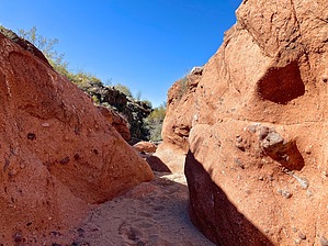
Little Used Trails North of Wickenburg by batman1   Overview OverviewThis hike uses two trails in the Sophie's Flat trail system north of Wickenburg. Trail A An 8-mile loop that begins and ends at Sophie's Flat Trailhead. Proceeding counterclockwise, the trail heads roughly north from the trailhead. It follows dry washes for short periods and crosses many more. Most of the crossings and points where the trail leaves washes are marked with signs or cairns. The trail also crosses several 4x4 roads. Occasionally, you hear quads and other vehicles in the distance, but traffic on the hiking trail is almost non-existent, even on weekends. The trail winds around a few peaks north of the trailhead before beginning its winding return. The last couple of miles of the trail are south of Blue Tank Road before returning to the trailhead.
An optional in-and-out route from the midpoint of Trail A. It heads north over a pass between two peaks and descends to a wash below to the north. At this point, signs and actual trail end, but the wash and/or quad trails can be followed 2 miles to the Hassayampa River just below Box Canyon. There are a few minor rocky spots to scramble down en route. Along the Hassayampa, there will be numerous SUVs, trucks, and other vehicles exploring the river. A quarter-mile up the Hassayampa, there is an interesting narrow that enters the canyon. You can explore it for a hundred yards or so before a drop would require technical climbing skills. The return route is a backtrack to trail A. Check out the Official Route and Triplog. Leave No Trace and +Add a Triplog after your hike to support this local community. | |||||||||||||||||||||||||||||||||||||||||||||||||||||||||||||||||||||||||||||||||||||