 Route Editor

| Guide | ♦ | 5 Triplogs | 0 Topics |
details | drive | permit | forecast | route |
stats |
photos | triplogs | topics | location |
| 20 | 5 | 0 |
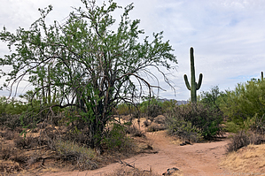
Less Green than Expected by KBKB  Overview OverviewThe Verde Trail is a 1.2-mile trail located in the northeast corner of McDowell Mountain Regional Park. At its northeast end, the Verde Trail provides access to the park from the community of Tonto Verde. At its southwest end, it intersects the North Trail at about 0.3 miles from the start of the North Trail when hiking it in the counterclockwise direction. (Go west from the North Trail Trailhead and turn right at the fork.) At the Tonto Verde end of the trail, limited parking is available on a wide gravel shoulder south of N Palo Fiero Rd just west of the entry to the park. Access to the park is provided via an unmanned gate; nearby is an "iron ranger" which is used to pay the walk-in entrance fee for McDowell Mountain Regional Park. If you drive to this trailhead, you will drive south on N Aguila Dr. At its southernmost end, N Aguila Dr. turns to the right so that you'll be heading westward on N Palo Fiero Rd. Look for the park entrance to the left immediately after making this turn. The shoulder mentioned earlier will be just beyond the entrance (also on the left).
Hike The Verde Trail is an easy trail to follow. Starting from the northeast end after entering from Tonto Verde, it proceeds in a mostly westerly direction, trending somewhat south, though also occasionally wandering back slightly to the north. At just under a quarter-mile, it'll cross a wash and then cross the same wash again just a short way (0.05 mile) later. Half a mile after that, it'll cross that same wash yet again. After proceeding another tenth of a mile (just under a mile along the trail total), it will cross a service road. A short while later, it crosses a small wash and then heads south and very slightly east. The trail then makes a gradual turn to the southwest, crossing one more wash before intersecting the North Trail at 1.2 miles. Once you get to the North Trail, you can hike the loop formed by the North Trail (in either direction) and then return via the Verde Trail. The North Trail loop will add 2.7 miles to the 2.4 miles of the Verde Trail, making it a hike of just over five miles total. The Verde Trail may also be hiked from the western end by first hiking the North Trail. In this case, I recommend proceeding eastward and turning back perhaps a quarter mile before reaching the east end where the views are less compelling. Even longer hikes are possible by incorporating the Chuparosa Trail which will be encountered midway around the loop comprising the bulk of the North Trail. Gate Policy: If a gate is closed upon arrival, leave it closed after you go through. If it is open, leave it open. Leaving a closed gate open may put cattle in danger. Closing an open gate may cut them off from water. Please be respectful, leave gates as found. The exception is signage on the gate directing you otherwise.
Check out the Official Route and Triplogs. Leave No Trace and +Add a Triplog after your hike to support this local community. One-Way Notice This hike is listed as One-Way. When hiking several trails on a single "hike", log it with a generic name that describes the hike. Then link the trails traveled, check out the example. | |||||||||||||||||||||||||||||||||||||||||||||||||||||||||||||||||||||||||||||||||||||||||||||


