Route Editor

| Guide | ♦ | 3 Triplogs | 0 Topics |
details | drive | no permit | forecast | route |
stats |
photos | triplogs | topics | location |
| 104 | 3 | 0 |
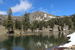
Highest Peak West of Interstate 5 by JimmyLyding Hike east/south on the Pacific Crest Trail from the Parks Creek Trailhead for a little less than 3 miles through a nice forest of Jeffrey pine with views to the south of the Scott Mountains 10 miles away and the meadows of Deadfall Creek immediately below. This section has very little elevation change, but that doesn't last long. At 2.9 miles continue straight onto the Sisson-Callahan National Recreation Trail instead of turning right to remain on the Pacific Crest Trail.
You might notice the lack of undergrowth around the lakes with in the reddish-orange soil with gray-green outcroppings. The peridotite and and serpentine soil, so named because someone thought most snakes are green, dramatically limits the number of plant species. Very few plants thrive in serpentine soil, and areas that have serpentine soil are known to harbor exceptionally rare plant species found nowhere else. The high peaks of the eastern Klamath Mountains are no exception. The northern foxtail pine is found only around the highest peaks in the eastern Klamath Mountains, and is one of the rarer conifers on earth. This is also where one can easily see pitcher plants that rely on the consumption of insects for nutrients. Some wildflowers manage to hang on in the harsh soil, but not many. At around 4 miles the Sisson-Callahan NRT passes the last of the trailside lakes, and begins to climb the ridge that runs off of Mount Eddy's southwest flank. The trail to Mount Eddy's summit is only 0.4 mile away at the crest of the ridge, and the hike gets serious from there. The only vegetation in this part of the hike are scattered northern foxtail pines, true alpine survivors, as the trail to the summit ascends 1,000 feet in 1.1 miles. I'm sure the summit is gorgeous a lot of the time, but it was not gorgeous when I got there. The wind was howling at at least 50 knots, probably more, and it was extremely cold. The wind chill was well below freezing judging by how long it took my hands to get unfrozen (30 minutes after I left the summit). There's a small spider hole on top where one person can hide out and sign the summit register in peace. There's also the ruins of a small fire lookout that has long since disintegrated into boards. I was surprised that the boards hadn't blown away in the wind, it was that strong. I concluded that setting up my tripod would be a waste of time because it would probably still be flying in the jet stream had I tried. The view from the summit is reputedly the best in Northern California, but Mount Shasta was mostly hidden by fast-moving clouds on my visit. I'm sure the view is world-class on calm, clear days. The summit is 5.5 miles and a little less than 2,300 feet from the trailhead. Check out the Official Route and Triplogs. Leave No Trace and +Add a Triplog after your hike to support this local community. | ||||||||||||||||||||||||||||||||||||||||||||||||||||||||||||||||||||||||||||||||||||||||