 Route Editor

| Guide | ♦ | 7 Triplogs | 0 Topics |
details | drive | permit | forecast | route |
stats |
photos | triplogs | topics | location |
| 114 | 7 | 0 |
vibrating and thrumming by Hippy   History HistoryHack canyon is said to be named after Haskell Jolly, who was known to locals as "Hack" and owned a nearby spring and ranch. The Hack Cyn Mine is in upper Hack Canyon, around 5.7 miles from Sunshine Road. This was a copper mine in WWI, and there is still evidence of a tramway used to haul ore to the canyon's rim for transport. "From the Hack Mine, 1,100 tons of uranium ore was shipped in 1951-52." (Tucson newspaper article quote from 2015). This mine and others in the area were closed and "reclaimed" in the 1990s. Tailings and such were bulldozed to fill in any open mineshafts.
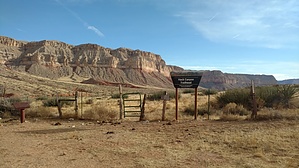
Hike Once at the actual trailhead you will literally have driven the first few miles INTO upper Hack Canyon. This road is super neat because you enter the canyon and travel down through the Kaibab Limestone, Toroweap Formation, and Coconino Sandstone! Your hike begins already down in the Hermit Shale! If your vehicle has made it all the way down to the trailhead, you'll probably be surrounded by cows, cow pies, and fencing. The BLM and Kanab Creek Wilderness sign awaits your attention, and a register is present for your autograph. There is a gate immediately behind these signs (see photos) please close it and latch the chain when you're through! (There are enough cows on either side) An undeniable use path takes off, and you can follow this 80% of the time. After the first few miles, you'll drop below the Hermit Shale further into the creekbed and down into the Supai Layers (Esplanade Sandstone, Wescogame Formation, Manakacha Formation, and Watahomigi Formation) On this trip, I didn't exactly pay attention to how far down into the Supai Group the trail goes but at least the first two or three formations! The creek abruptly widens and spills out into Kanab Creek after 6.69 miles of happy hiking from the register. From there one may easily access all sorts of backpacking areas via Kanab Creek or just hopping up on the Ranger Trail below Jumpup Point. To return to your vehicle, you head right back up Hack Canyon creekbed. If the creekbed is flowing somehow, there are multiple "high pass" routes you can spot along your way down the creekbed. Gate Policy: If a gate is closed upon arrival, leave it closed after you go through. If it is open, leave it open. Leaving a closed gate open may put cattle in danger. Closing an open gate may cut them off from water. Please be respectful, leave gates as found. The exception is signage on the gate directing you otherwise. Check out the Official Route and Triplogs. Leave No Trace and +Add a Triplog after your hike to support this local community. One-Way Notice This hike is listed as One-Way. When hiking several trails on a single "hike", log it with a generic name that describes the hike. Then link the trails traveled, check out the example. | |||||||||||||||||||||||||||||||||||||||||||||||||||||||||||||||||||||||||||||||||||||||||||


