 Route Editor

| Guide | ♦ | 7 Triplogs | 0 Topics |
details | drive | no permit | forecast | 🔥 route |
stats |
photos | triplogs | topics | location |
| 15 | 7 | 0 |
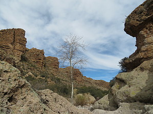
Rough road. Easy hike. Small surprise. by Steph_and_Blake   Overview OverviewAfter enduring a rather rough 3-mile drive to the trailhead, this is an enjoyable hike along and through a stretch of Tortilla Creek to a small, clear spring. Warning The drive from Apache Trail (Route 88) to the trailhead requires a HIGH clearance, 4-wheel drive vehicle. It's our opinion that it shouldn't be attempted in a stock high clearance vehicle. There are three spots in the first 1/4-mile that could do some severe damage if you don't have a lift kit and skid plates. It took us about 45 minutes to cover the 3 miles. The other option is to leave your vehicle at the parking area right at the junction of Apache Trail and FR213 and hike in.
According to Carlson and Stewart's "Superstition Wilderness Trails West... Tortilla Ranch was considered part of the Reavis Ranch operation...The land at the headquarters ' site was never homesteaded and remains in federal ownership today." About a half-mile from the trailhead is a corral, the concrete slab upon which the barn once stood, and what looks like very beefy clothesline poles (T-shaped). These poles were used to hold up the fabric to make shade. At the trailhead stands a shot-up water tank (this IS Arizona!), a cement trough, and parts of a broken windmill are on the ground. Hike Two trailheads are leading from the parking area. One is to the east - JF Trail (106). The other, Peters Trail (105), is to the west. This hike uses Peters Trail, which begins very near the water tank and downed windmill. From the Peters Trail sign, follow the worn footpath along Tortilla Creek. Along the way, you'll see scrub oak, manzanita, juniper, prickly pear, some cholla, enormous agaves, and sycamore trees. There are numerous crossings of Tortilla Creek with pretty good "cairn-age" to guide you from one side to the other. After about 3/4 of a mile, you'll leave Tortilla Creek and follow a side drainage to Kane Spring. Tortilla Mountain is seen on your right. The gradual ascent up the drainage to the north of the peak looked to be the best approach if it weren't for the very dense and (likely) thorny vegetation. If you're not keen on leaving behind lots of fabric and skin, it might be possible to approach the top from the east, but it looked like an extremely steep, perhaps dangerous, climb. At about 1.5 miles in, you'll start to feel as if you're gaining in elevation, but nothing strenuous. Here there are two other springs you can search for - Indian Spring Number One (on your left) and Indian Spring (on your right). We'd read that they were dry and didn't bother to locate them. After ten more minutes, you'll see a side-path on your left with a large cairn. Take the path down to Kane Spring. It's not big, perhaps 2.5 feet in diameter, but the water's clear and a pretty sight for a desert hike. To the left of the spring are some large rocks that would make for a nice lunch spot. We think this would be an excellent hike for folks of all ages, incredibly fun for kids when there's water, and even more scenic in the fall. The small surprise came when we were making our way back to Apache Trail. While driving through an open gate (which has a wooden "structure" above it (similar to the entryway to many ranches - I don't know what it's called), we spotted a half-hidden jar to the right. Remembering that we'd seen a similar jar someplace, we'd been a year or so ago, I jumped out of the truck to check it out. Inside was a register with numerous entries. I paged back and found our first notation from December 2016. It brought a smile to our face and solved the mystery of where we'd seen that jar! Camping We didn't notice any particularly good camping spots along the trail, but folks have camped at the trailhead. Gate Policy: If a gate is closed upon arrival, leave it closed after you go through. If it is open, leave it open. Leaving a closed gate open may put cattle in danger. Closing an open gate may cut them off from water. Please be respectful, leave gates as found. The exception is signage on the gate directing you otherwise. Check out the Official Route and Triplogs. Leave No Trace and +Add a Triplog after your hike to support this local community. One-Way Notice This hike is listed as One-Way. When hiking several trails on a single "hike", log it with a generic name that describes the hike. Then link the trails traveled, check out the example. | ||||||||||||||||||||||||||||||||||||||||||||||||||||||||||||||||||||||||||||||||||||||||||||||||||||||||||||||||||||||||||||||||||||||||||||||||||||||||||||||||||||||||||||||||||||||||


