Route Editor

| Guide | ♦ | 2 Triplogs | 0 Topics |
details | drive | no permit | forecast | map |
stats |
photos | triplogs | topics | location |
| 4 | 2 | 0 |
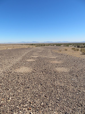
A geoglyph is a large design or motif (generally longer than 4 metres) produced on the ground and typically formed by clastic rocks or similarly durable elements of the landscape, such as stones, stone fragments, live trees, gravel, or earth. A positive geoglyph is formed by the arrangement and alignment of materials on the ground in a manner akin to petroforms, while a negative geoglyph is formed by removing patinated clasts to expose unpatinated ground in a manner akin to petroglyphs." The Mule Mountain geoglyphs are negative geoglyphs, also known as intaglios (a word used to describe a particular type of printing). The sign located at the Mule Mountain Archaeological site reads: "This terrace contains a branching Indian trail and trail circle worn into the desert pavement. Although the purpose of trail circles is not definitely known, they may have been used by the Indians for performing dances called "circle dances". The terrace also contains groups of circles in parallel rows and horseshoe shapes scraped into the pavement surface. When these circles were made or for what purpose is at present unknown. They may be aboriginal or they may be a result of General Patton's desert training activities during World War II.
The drive out to the intaglios is sandy and bouncy and follows a powerline for much of the way, then veers off to the southwest. In fact, you could easily drive right past the intaglios if you didn't know what you were looking for, except that they're fenced off and there's a small sign (riddled with bullet holes) at the entrance. The desert floor, or "terrace" is flat and easily traversed. The individual circles are about 15 - 20 inches in diameter and the horseshoe shapes are perhaps about 12 to 15 feet wide. There are numerous horseshoe shapes, mostly all lined up close to the ancient path to Corn Spring. The intaglios, while visible at ground level, would best be viewed from an aerial perspective. If only we had wings! It was fun to ponder how or why the circles were made and if they had a ceremonial purpose or perhaps a far more practical one. If you've got the vehicle to get out there, it's worth the time and effort if you're in the area. Check out the Triplogs. Leave No Trace and +Add a Triplog after your walk/tour to support this local community. | ||||||||||||||||||||||||||||||||||||||||||||||||||||||||||||||||||||||||||||