Route Editor

| Guide | ♦ | 2 Triplogs | 0 Topics |
details | drive | no permit | forecast | route |
stats |
photos | triplogs | topics | location |
| 22 | 2 | 0 |
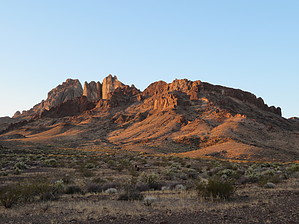
A short introductory hike to the Turtle Mountain Wilderness. It begins near an old mine, offers views of Mexican Hat and far away mountain ranges, and ends with the potential to find a unique petroglyph. Hike After checking out the Lisa Dawn mine (now covered by a very hefty metal "lid"), we picked up the trail to Mohawk Spring. Being out in the middle of nowhere it was surprising to find the trail in such good condition and it was evident that substantial work had been put into building it. The path gently curved around two unnamed peaks, generally in a southwestern direction, and offered various views of Mexican Hat peak (so-named for its resemblance to a sombrero) and distant mountain ranges.
During our visit the springs were not flowing, but we assumed the main one would have been located near or at the base of a large (by Mojave desert standards) tree. Above the tree and a little to the right, the spring had been dug out, but it was also dry. We searched around for the Blueprint Petroglyph but didn’t luck out. On the return trip, with only about a ¼ mile to get back to the start, we took a less-used side trail on our left to check out two piles of white rocks. Upon examination the rocks had been painted and the second one (above the trail on the left) had the writing “Mohawk #1” and “Nend Center”. We pondered the significance of the writing and why the rocks were there but came up with no definitive answers. Perhaps mining claims? It was a very pleasant hike that left us wondering. Check out the Official Route and Triplogs. Leave No Trace and +Add a Triplog after your hike to support this local community. | ||||||||||||||||||||||||||||||||||||||||||||||||||||||||||||||||||||||||||||||||||||||||||||