This hike materialized after seeing the words “Obsidian Deposit” on a map on a blogger’s website. That was it. No more information could be found. So, with different expectations (or perhaps none at all) we set out to see it for ourselves.
We parked ¾ of a mile short of the trailhead and followed the road to the end. Once there we knew the deposit was located up the drainage to the southwest. The trail was easy to find and, focused on finding the obsidian, we almost missed the jacuzzi tub that had been constructed in the drainage. Made of sandbags and cement, it was holding water – though of the murky and green slime variety. It wasn’t obvious how the spa was filled, however, as it probably hadn’t rained there in months.
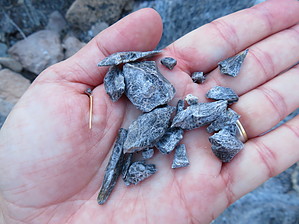
Onwards up the drainage we were on the lookout for a shiny, black, glassy obelisk when the trail suddenly ended. We were instead staring at a large vein of black and white, crumbly rock. We picked up chunks of it and were quite puzzled in that our mental image of obsidian was vastly different from what we were seeing. Wade chipped away at a piece and discovered that, in some cases, you could work it down to a hard, solid piece (though still black and white in color). Perhaps obsidian that matches up with our mental image had been found in the small tunnel dug into the side of the vein? With everyone’s pack slightly heavier than when we came upon the deposit, we turned around and hiked back to our trucks.
When hiking several trails on a single "hike", log it with a generic name that describes the hike. Then link the trails traveled, check out the example.
WARNING! Hiking and outdoor related sports can be dangerous. Be responsible and prepare for the trip. Study the area you are entering and plan accordingly. Dress for the current and unexpected weather changes. Take plenty of water. Never go alone. Make an itinerary with your plan(s), route(s), destination(s) and expected return time. Give your itinerary to trusted family and/or friends.
Permit $$
None
Directions
Road
Strictly 4x4
To hike From Blythe, take Route 95 north 72 miles. Turn left(west) on Turtle Mountain Road. Turn left onto Mohawk Springs Road. From here the signage becomes confusing and/or illegible and/or non-existent. Our best advise is to study maps, plot a route, and use a GPS device to find the obsidian deposit.
 Route Editor


