Virginia May Mine, CA • Hike
 

Virginia May Mine, CA

Guide 2 Triplogs Mine 0 0 Topics
 
3.5 of 5 
Fav
Wish
0
details
drive
no permit
forecast
route  
stats
photos
triplogs
topics
location
20 2 0
Statistics
tap icons for details
Difficulty 1.5 of 5
Route Finding 1 of 5
Distance One Way 4.3 miles
Trailhead Elevation 1,497 feet
Elevation Gain 1,110 feet
Accumulated Gain 1,270 feet
Avg Time One Way 3.5 hours
Kokopelli Seeds 8.53
 Interest Historic
 Backpack Possible - Not Popular
feature photo
Photos Viewed All MineFollowing
Will recalculate on button tap!
6  2018-02-07 AZWanderingBear
14  2018-02-07 Steph_and_Blake
Author
author avatar Guides 100
Routes 63
Photos 2,548
Trips 184 map ( 820 miles )
Age 73 Male Gender
Location Grand Junction, CO
Associated Areas
list map done
Inland Region
Historical Weather
Trailhead Forecast
Radar Map
Expand Map
Preferred Feb, Jan, Dec, Nov → Early
Seasons   Late Autumn to Late Spring
Sun  5:59am - 5:41pm
Official Route
 
0 Alternative
 
 Water
Nearby Area Water
[ View More! ]
Culture  Nearby

Caution
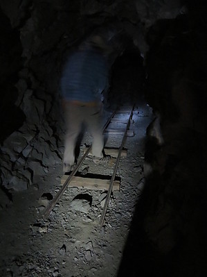
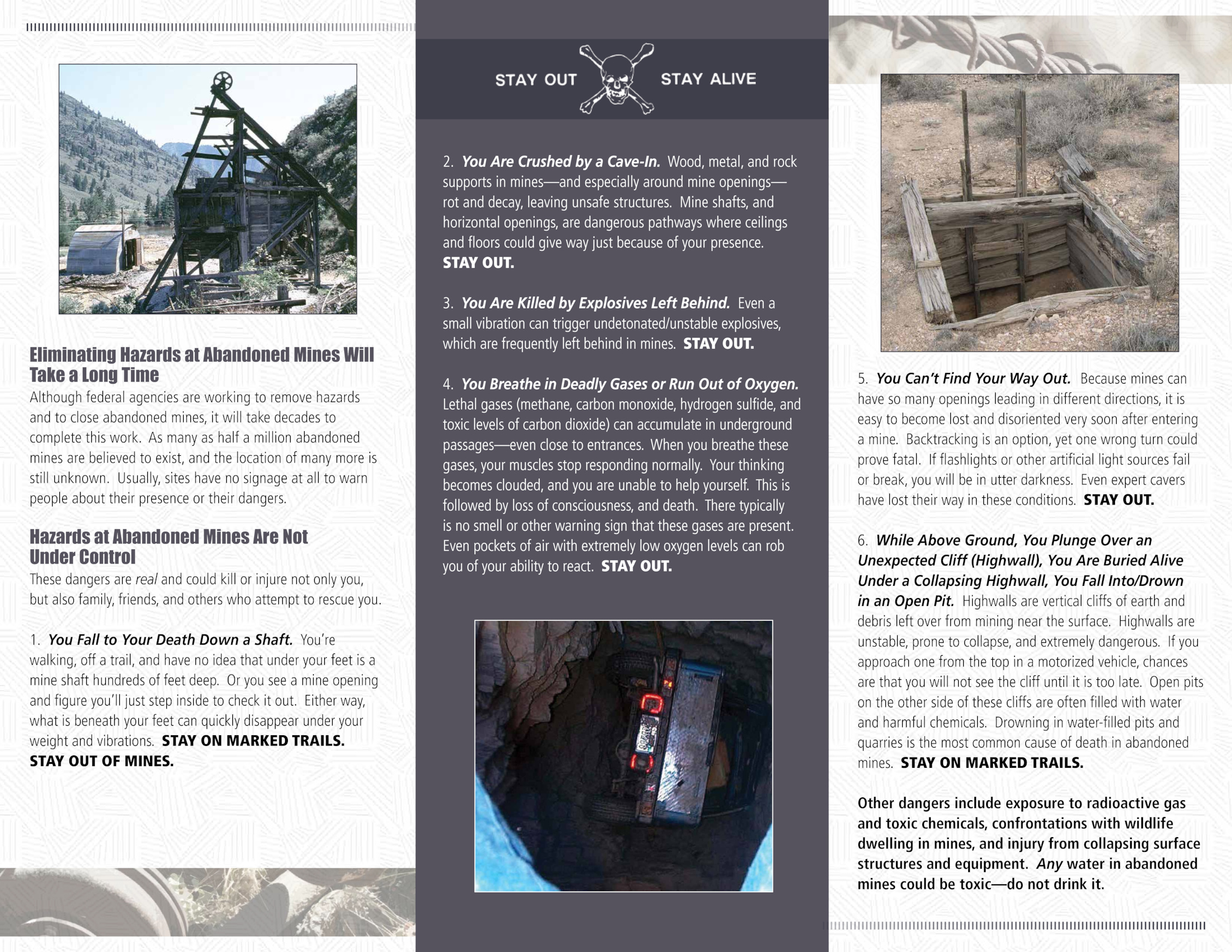
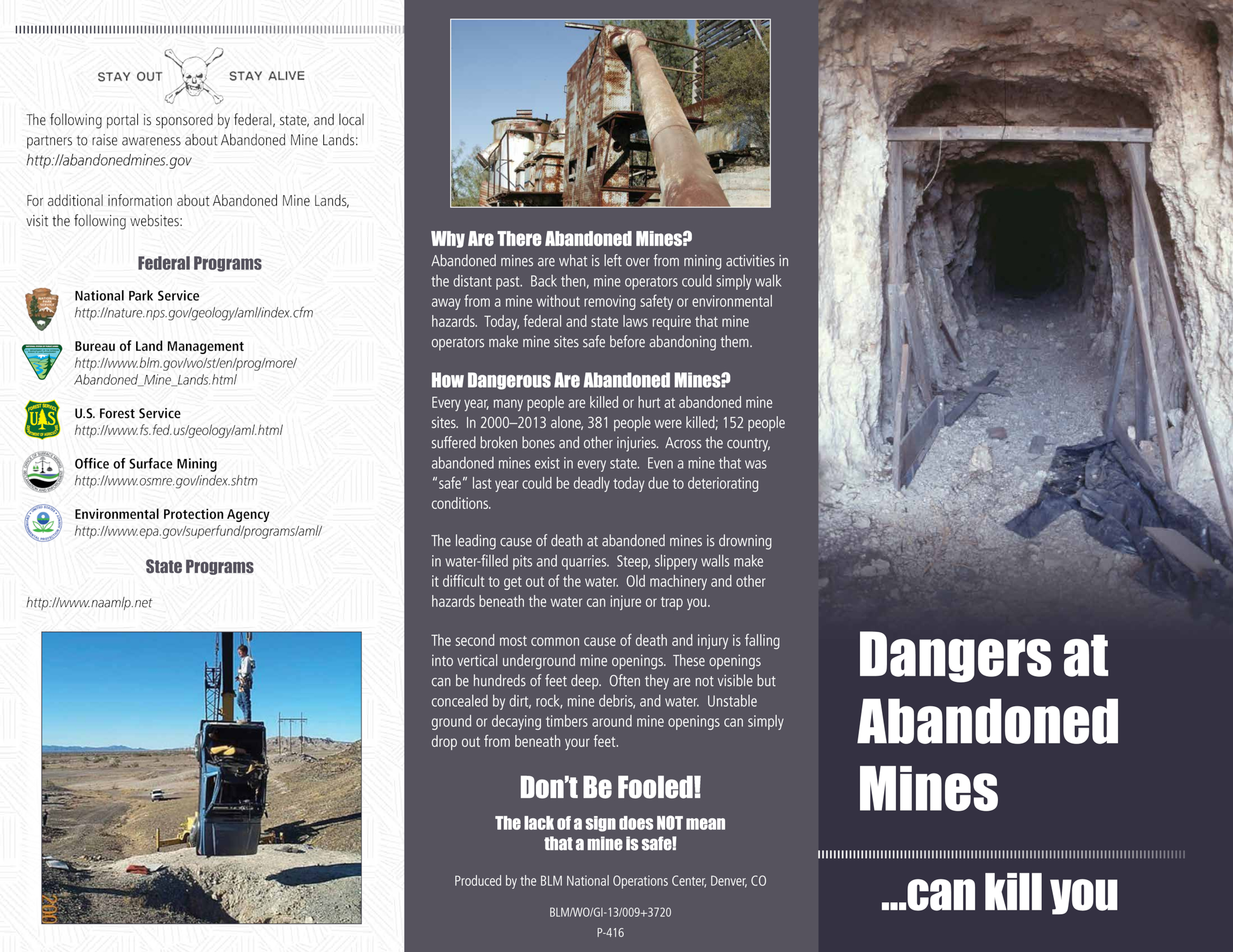
Entering a mine is dangerous. Please see this safety brochure from the BLM.
Page1, Page 2
Hike
This hike begins at the boundary of the Turtle Mountain Wilderness and follows an old road up to the Virginia May Mine and camp. There is a constant, but gradual ascent, as you get closer and closer to the mountains. There’s an old, rusted, gutted car to check out and a deep wash with conglomerate walls to drop down into along the way. But that’s about it in terms of interest.

Just when you’re thinking “This is kinda’ boring and it’s getting really hot out here”, the road leads you into a canyon and suddenly you see the remains of a mining camp. Concrete foundations, broken pottery, nails, rusted cans, piping, remains of a vehicle, and various metals parts are strewn about. There’s even more down in the wash. Fun to ponder what this metal piece was used for and was this blue ceramic piece part of a mixing bowl?

With your interest piqued, you continue further along the road in search of the mine that warranted lugging all that equipment and cement out to the camp. At this point the hike has a noticeable elevation gain and the road becomes quite rocky as it winds its way up the canyon along the hillsides. A side-road cuts back to the left and takes the hiker to a large mine. We continued on the main road and just when we were wondering if the road would ever end, to our left was the Virginia May mine!

With flashlights and headlamps we entered the mine, some more tentatively than others. It was about 5 feet across and nearly 7 feet tall. Wood stakes with wires attached came out of the ceiling at regular intervals and Wade guessed they were for electric lighting. We walked into the mine for, say, 75 – 100 feet until it was partially blocked off. It continued on, but would have been an army crawl for humans. We turned around, had lunch, and had a satisfied feeling upon our return to camp. Worth the effort.

Check out the Official Route and Triplogs.

Leave No Trace and +Add a Triplog after your hike to support this local community.

2018-02-11 Steph_and_Blake

    One-Way Notice
    This hike is listed as One-Way.

    When hiking several trails on a single "hike", log it with a generic name that describes the hike. Then link the trails traveled, check out the example.
    WARNING! Hiking and outdoor related sports can be dangerous. Be responsible and prepare for the trip. Study the area you are entering and plan accordingly. Dress for the current and unexpected weather changes. Take plenty of water. Never go alone. Make an itinerary with your plan(s), route(s), destination(s) and expected return time. Give your itinerary to trusted family and/or friends.

     Permit $$
    None


     Directions
    or
    or
     Road
    FR / Jeep Road - Car possible when dry

    To hike
    From Blythe, CA, drive north on Route 95 for 46 miles to the Vidal Junction mini mart/gas station. Turn left (west) onto Route 62 and drive 8.3 miles. Turn right onto dirt road. See GPS route as there were little-to-no roads signs once we turned off of Route 62.
    page created by Steph_and_Blake on Feb 11 2018 10:18 am
    helpcorrectionissue

    end of page marker