Route Editor

| Guide | ♦ | 5 Triplogs | 0 Topics |
details | drive | no permit | forecast | route |
stats |
photos | triplogs | topics | location |
| 62 | 5 | 0 |
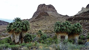
Mo Pah Wah Tuya! by azbackpackr The route-finding for the hike is very easy at first: just follow the wash upstream. There are easy ways to follow it, and harder ways, but just follow it. Eventually, after almost 4 miles, it starts to narrow, and you climb up onto a bench, and then you will soon see the tops of the palms in the near distance. At this point you will have almost passed Mopah Peak. Once you see the palms, you may also find there is a trail on the top of the bench, made by burros and bighorn sheep on their way to water.
Near the palms you may find signs of ancient Native Americans having camped nearby. They used pottery, they did flintknapping (made arrowheads), and they carved petroglyphs. If you find any pottery shards or any rock chips left over from flintknapping, please just take photos of these items and return them to where you found them. Never ever stack them in a pile on a flat rock, and if you find them stacked this way, scatter them! If you find any petroglyphs, take photos, do not touch. The oils from your hands can damage them. On my several visits to the palms I hoped to see bighorn sheep, but saw none, and in fact, saw only very old droppings--nothing recent. Also, there are no recent signs of burros in the area. Check out the Official Route and Triplogs. Leave No Trace and +Add a Triplog after your hike to support this local community. | |||||||||||||||||||||||||||||||||||||||||||||||||||||||||||||||||||||||||||||||||||||||||||||||||||