Route Editor

| Guide | ♦ | 4 Triplogs | 0 Topics |
details | drive | no permit | forecast | route |
stats |
photos | triplogs | topics | location |
| 55 | 4 | 0 |
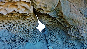
Through the Eye of the Needle by azbackpackr  Overview OverviewThis is a hike to an interesting small butte with a slim hole through the middle of it, hence the "needle" appellation. The "Rovey" in question is undoubtedly Carl Rovey, a long-time resident of Lake Havasu City, native Arizonan and dairy farmer. Rovey was an in-law relative of chainsaw magnate Don McCullough, who developed Lake Havasu City and London Bridge. Rovey's obituary. Rovey's Needle butte seems to be a hunk of sandstone (in a volcanic desert?) if I am not mistaken. I'm not a geologist. Maybe it's volcanic tuff? Anyway, the weird rock formations there are really cool. There are big ledges suitable for camping on both sides of the eye of the needle, although you'd have to backpack your gear up to them. The formations, caused by "alveolar" or "honeycomb" weathering, around the eye of the needle, are very photogenic. The presence of salts is apparently the reason for this type of erosion.
This is almost the furthest north and west edge of saguaro habitat, (although there is a good bunch of them on the west side of the Hualapais, further north). It was fun seeing the "nurse tree" taking care of the baby saguaros. We don't see that around here too much. General Directions Just to the north of the parking spot there is a little canyon. Hike north up this. It will bend around to the east fairly quickly. A little less than two miles from the starting point watch for another canyon coming in from your right, and a big cairn to mark it. Turn up this side canyon. You can see from my GPS route that we went too far up the main canyon because we missed seeing that cairn. We missed it because people had been setting up cairns all along the entire route, for no good reason--they were everywhere! (After that, I kicked down all the cairns that didn't mark junctions.) You will climb up several dry waterfalls during the hike, in the main canyon and also in the side canyon. One of them has a rough trail leading around it, to avoid having to climb up the pour-off. After following this side canyon for about a quarter mile, the terrain widens out, and you will find a trail leading off to the east. Very soon you will be able to see the top of the butte. A good trail contours along the side of a hill, leading to the butte. From this part of the trail you can see the hole through the butte. When you arrive at the butte you will find a well-used trail going up to a ledge on the east side of it, from where you can climb through the eye of the needle, to a ledge on the other side of it. Then you can easily hike down this ledge and go around the north side of the butte and meet up with the trail you came in on. Retrace your steps to get back to the parking area. Check out the Official Route and Triplogs. Leave No Trace and +Add a Triplog after your hike to support this local community. | |||||||||||||||||||||||||||||||||||||||||||||||||||||||||||||||||||||||||||||||||||||