username
X
password
register
for free!
help


Little Horn Summit, AZ

Guide 4 Triplogs  0 Topics
  4 of 5  
Fav
Wish
0
details
drive
no permit
forecast
route  
stats
photos
triplogs
topics
location
82 4 0
Statistics
tap row or icons for details
Difficulty 2.5 of 5
Route Finding 3 of 5
Distance Round Trip 6 miles
Trailhead Elevation 1,737 feet
Elevation Gain 1,363 feet
Accumulated Gain 1,400 feet
Avg Time Round Trip 5 hours
Kokopelli Seeds 13
 Interest Off-Trail Hiking & Peak
 Backpack No
feature photo
Photos Viewed All MineFollowing
Inaugural Calculation on Button Tap!
18  2024-11-29 DixieFlyer
5  2021-02-28 ScaredyCat
41  2018-04-08
Five Little Horns-Little Horn Mountains SE
FLYING_FLIVER
18  2018-03-05 Jim
Author
author avatar Guides 73
Routes 176
Photos 10,174
Trips 2,324 map ( 14,158 miles )
Age 46 Male Gender
Location
Associated Areas
list map done
Southwest Region
Historical Weather
Trailhead Forecast
Radar Map
Expand Map
Preferred Jan, Dec, Feb, Nov → 10 AM
Seasons   Early Autumn to Late Spring
Sun  6:11am - 6:56pm
Official Route & 2 Rts
 
1 Alternative


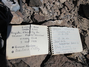
Big Horns on Little Horn
by Jim

 
Little Horn Summit in the Little Horn Mountains is an isolated range in part of the state where few venture and fewer seem to bother to make the summit. It isn't a rugged area or a big obvious mountain like Castle Dome, Woolsey, or Big Horn, but it has some pretty good views, and being much further from Phoenix, it is a lot quieter out here.


The hike is all off-trail but very easy to find. It is pretty much a cross country trek up a wash, gaining a basalt slope, and then an easy walk across a rocky ridge to the summit. This is a pretty nice mountain, as it isn't covered in cholla, and the rock is neither steep nor unstable. I chose a route that minimized elevation loss, but your route will vary and could include more AEG. Return how you came, or descend a different slope to explore on your way back.
remove free decal offer
I used the wash on the east side of the road and opposite a large hill on the west side of the road, which is south of the small pass. At present, a trailhead of sorts exists where an old trailer frame is rotting. My GPS route comes from my car, and I parked at a campsite, in case you want to use that and walk some road. Either way, you will start in the area where the road parallels the wash, leave from that area, and head up the dry wash to the ridge. Cross the terrain, and aim for the summit.

I saw a bighorn ram when I was almost near the summit, and I can see desert wildlife being common out here. The views are nice, too. The summit is nothing special, just a high point on the ridge in the volcanic rock region of western Arizona south of I 10.

2018-03-05 Jim


    Check out the Official Route and Triplogs.
    Leave No Trace and +Add a Triplog after your hike to support this local community.
    WARNING! Hiking and outdoor related sports can be dangerous. Be responsible and prepare for the trip. Study the area you are entering and plan accordingly. Dress for the current and unexpected weather changes. Take plenty of water. Never go alone. Make an itinerary with your plan(s), route(s), destination(s) and expected return time. Give your itinerary to trusted family and/or friends.

     Permit $$
    None


     Directions
    or
     Road
    FR / Dirt Road / Gravel - Car Okay

    To hike
    Exit # 53 from I 10 and drive south on Hovatter Road. Cross the CAP canal, the road curves west, and take the left on to Hovatter Rd, which is dirt. Follow this through some curves and on as it heads SW towards Coyote Peak. After several miles crossing a plain, you will arrive at a T intersection, and the road coming in from the north should be Vicksburg Rd. Go left and south, continuing across the plain, and the terrain begins to gain some elevation. After leaving La Paz County, you'll go over a small pass between two hills. From here, find a spot to park, either a campsite or near the trailhead: a pullout near the wash with a trailer frame beside the road.
    page created by Jim on Mar 05 2018 8:48 pm
     90+° 8am - 6pm kills
    helpcorrectionissue

    end of page marker