Route Editor

| Guide | ♦ | 23 Triplogs | 0 Topics |
details | drive | no permit | forecast | 🔥 route |
stats |
photos | triplogs | topics | location |
| 346 | 23 | 0 |
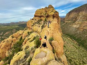
Don't rock the boat! by DixieFlyer  Overview OverviewThis guide provides a route and description of a hike to Battleship Mountain in the Superstitions that begins and ends at Canyon Lake Marina. This hike is longer and has more elevation gain than by hiking Battleship from the First Water Trailhead. Hike This hike is a lasso loop configuration that circles around Battleship Mountain in a counterclockwise fashion. After parking your vehicle in the Canyon Lake Marina parking lot (it is best to park away from the buildings near SR-88), cross SR-88 and begin the hike on Boulder Canyon Trail #103. After hiking just over 3 miles you will come to LaBarge Creek. At this point you will have a net elevation gain of about 100 feet; however, you will have ascended around 1,000' and descended around 900'.
You will be following a cairned use trail that goes to a saddle below the south end of Battleship. Once at the saddle, continue upward to the precipice of Battleship Mountain. Here is where the fun begins. In short order you will come to a near vertical rock that you have to climb up 6'-8'; there are some decent handholds and footholds, but this climb is not for everybody. After that it is clear sailing for a while, although you will have to do some rock scrambling in a few places. The route is mostly intuitive to follow, but a few places offer some route finding challenges. As you get closer to the summit, you'll cross the well known bridge that is about 3' wide; there are some steep dropoffs on either side, so be careful. Shortly past the bridge is another near vertical wall that you have to negotiate. Past that point there is a bit more rock scrambling and route finding ahead of you, but before you know it you will be at the Battleship Mountain Summit. While at the summit, enjoy the 360 degree views of the surrounding area, including views of Geronimo Head and Malapais Mountain. After taking a well deserved break at the summit, retrace your route to get back off the mountain. Once back at the saddle below the south end of the mountain, instead of turning right to go back to Boulder Creek, turn left and take a use trail down to LaBarge Creek. You will drop down next to LaBarge Box, and it is well worth walking 500 feet or so into the box canyon to enjoy the awesome vibe that you get there. At this point you will head NNW in LaBarge Creek back to the Boulder Canyon Trail; once back at the Boulder Canyon Trail, turn right and you will go back to the trailhead. It is easy to miss the turn from LaBarge Creek onto the Boulder Canyon Trail, as there is no signage; thus, if you are not familiar with the area it would be prudent to have a GPS track with you. Warning There a couple of items that should be mentioned about potential danger on this hike. First, those that are uncomfortable with rock scrambling and/or who have a fear of heights might want to avoid this hike. The HAZ guide to hiking to Battleship from the First Water Trailhead puts it quite nicely: To the individual not comfortable with heights, this hike has the potential to be a real life nightmare. That being said, there is no technical climbing involved, and at no time did I feel like I was at any real risk of falling. "Exposure" is a term used by climbers to describe the degree of vulnerability in the event of a fall. Although there is some very real exposure to be encountered on this hike, the risk of falling itself is extremely minimal. Therefore, as is mostly the case, dealing with the element of exposure is more of a psychological battle than a physical one. Second, you will be hiking through a couple of creeks, which oftentimes have little if any water in them. However, there can be times after periods of rain where there could be quite a bit of water in the creeks. This may result in nothing more than a nuisance by having to do some rock hopping to keep your feet dry. However, after periods of heavy rain there could be some substantial amounts of water flowing through the creeks, particularly in LaBarge Box. You don't want to be caught in a flash flood, so it would be prudent to check the weather forecast before attempting this hike -- and it would not be advisable to be negotiating the rocks on Battleship Mountain when it is wet anyway. Check out the Official Route and Triplogs. Note This is a moderately difficult hike. Leave No Trace and +Add a Triplog after your hike to support this local community. | ||||||||||||||||||||||||||||||||||||||||||||||||||||||||||||||||||||||||||||||||||||||||||||||||||||||||||||||||||||||||||||||||||||||||||||||||||||||||||||||||||||||||||||||||||||||||||||||||||||||||||||