 Route Editor

| Guide | ♦ | 14 Triplogs | 0 Topics |
details | drive | no permit | forecast | 🔥 route |
stats |
photos | triplogs | topics | location |
| 247 | 14 | 0 |
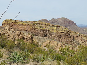
out-of-town guest special by Steph_and_Blake  Overview OverviewThis is a hike that allows one to view the rugged beauty of this part of Tonto National Forest, Canyon Lake, distant views of Four Peaks and the Superstitions, and a sneak-peak at the Salt River. There are also pretty quartz "flowers" to see along the hike. Warning While this hike is on the short side and doesn't have an enormous amount of elevation gain, it could be scary for folks not accustomed to (a) the unstable, rocky footing common to the area and (b) the narrow path on the side of a steep hillside.
With out-of-town guests wanting a short-ish hiking experience without a lot of "huffing and puffing", we chose what we call the "Quartz Cave" out near Black Cross Butte (3351). We figured they could enjoy the view of the Goldfields along the drive out Route 88, we could stop at the overlook of Canyon Lake, and we could do a little bit of (very) light off-roading on bumpy, gravelly FR80. We also thought it would give them a taste of what hiking is like in this "neck of the woods". The hike starts from the same trailhead as Black Cross Butte 3351. Initially, it heads due north up some volcanic tuff to a sorry-looking barbed wire fence. Cross over the fence and take an immediate left (headed west). If you've hiked up to the top of Black Cross Butte in this clockwise direction, this will be very familiar to you. The trail hugs the base of Black Cross Butte, taking you past several dry pour-overs, and in and out of small drainages coming off of the Butte. The ascent is fairly gradual, but the exposure gets greater and greater, the path narrows, and the footing worsens. Keep your eye out for cairns as they will keep you on the path and from going astray. At about 0.7 - 0.8 miles into the hike, the trail takes a strong right and gets you up a light scramble to a saddle via numerous switchbacks. You'll arrive at a very large rock with a flat-ish top. This would be an excellent place to take a break, walk due north to check out the river and the housing for the dam employees, and get your first view of the "Quartz Flower Cave" (due northwest). Black Cross Butte looms above you to the east. From the big rock, descend towards the cave. The trail is well-defined, especially as you walk through some grassy areas, and might be an easy relief to your fellow hikers not used to scratchy, pokey, rocky Sonoran desert hikes. As you approach the bottom of a small valley about halfway between the big rock and the Cave, keep your eye out for white, slightly pink, flower-shaped (think fully-opened roses) quartz rocks scattered on the ground. Chalcedony. Sadly, there aren't as many around as when we were first there years ago, but venture out a bit and you'll see more. Once you've seen enough of the rock, continue on the trail up to the cave. The cave itself isn't vast, but it might be fun for out-of-town guests. Have a seat, enjoy lunch, and take in the views. And, if your guests are up for it, add another mile to the hike and find the cross up on Black Cross Butte. If not, retrace your steps to the beginning. Water Sources None. Check out the Official Route and Triplogs. Leave No Trace and +Add a Triplog after your hike to support this local community. One-Way Notice This hike is listed as One-Way. When hiking several trails on a single "hike", log it with a generic name that describes the hike. Then link the trails traveled, check out the example. | |||||||||||||||||||||||||||||||||||||||||||||||||||||||||||||||||||||||||||||||||||||||||||||||||||||||||||||||||||||||||||||||||||||||||||||||||||||||||||||||||||||||||||||||||||||||||||||||||||


