Route Editor

| Guide | ♦ | 5 Triplogs | 0 Topics |
details | drive | no permit | forecast | 🔥 route |
stats |
photos | triplogs | topics | location |
| 27 | 5 | 0 |
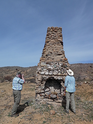
More Questions than Answers by Steph_and_Blake   Overview OverviewAn easy hike on old mining roads takes you past mines, abandoned structures, pretty rocks, and a rather unusual fireplace. Warning The larger mine is rather deep and there is no fencing around it.
While little can be found on the internet about the Brooklyn mine (other than it was supposedly started in 1907 and was an intermittent operation until 1970), I did dig up (pun intended) a digitized document that discusses the Brooklyn - Arizona Mining Company. The dates on the document correspond with a mine starting up around 1907 and the location noted in the document is the "Squaw Creek mining district", so I think it's safe to assume they are one in the same. The majority of the document seems to be aimed at potential investors in that it extolls the numerous virtues of the Brooklyn Mining Company with many a superlative. Here is a sampling of interesting and/or amusing tidbits: * A "good wagon road" runs from the town of Mayer to the site. The road must have been in much better shape back then! * The Humboldt and Verde Valley Railway Company would soon run through the Squaw Creek mining district "thus ensuring the very best transportation facilities". We saw no evidence of a railway in the vicinity. * The Brooklyn mine was reported as having the "makings of one of the greatest copper-producing mines in the country". Yet this was the only substantial document regarding the Brooklyn Mine I could find online. * The end of the document urged the reader that if he or she wanted to gain some of the earnings from the mine one should "secure your stock EARLY AND GET STARTED RIGHT". The full document. Hike The hike begins at an abandoned stone and concrete building. The building no longer has a roof but must have at some point as the interior walls were plastered. Perhaps this was the dining room/kitchen/store mentioned in the above document? Curiously, there were parts of the building that appeared to be chimneys, but we couldn't find any fireboxes for wood burning. Moving in a clockwise direction, you next come to a large, free-standing fireplace. Above the (missing) mantle the builders had embedded colorful stones to decorate the structure. What confused us, however, is that the fireplace appeared to be facing outwards of the former building. The ground behind the fireplace's opening is level and concrete footings are still there. The ground in front of the fireplace is sloped, not very large, and shows no remains of a building. At the top of the back and sides of the chimney are remnants of a metal roof. Perhaps the builders purposely constructed the fireplace to face the outside to keep the building cool? Continuing on the old road (watch out for that rattler!), headed now southeast, you'll come across a concrete pad strewn with an even layer of the same pretty rocks that decorated the fireplace. They're a beautiful white quartz with flecks of bright blue and deep green. Why were they all brought here and not piled up near the mine shafts? What was the purpose of the underlying concrete pad? After leaving the pretty rocks you arrive at what appears to be the powder house. The walls, floor, and ceiling are made of thick concrete. There is no mystery here. Following the road further south takes you past one large mine, tailings, and a couple of smaller dig sites. From here, travel due west, over the desert, to your starting point. Check out the Official Route and Triplogs. Leave No Trace and +Add a Triplog after your hike to support this local community. | ||||||||||||||||||||||||||||||||||||||||||||||||||||||||||||||||||||||||||||||||||||||||||||||||||||||||