 Route Editor

| Guide | ♦ | 2 Triplogs | 0 Topics |
details | drive | no permit | forecast | 🔥 route |
stats |
photos | triplogs | topics | location |
| 20 | 2 | 0 |
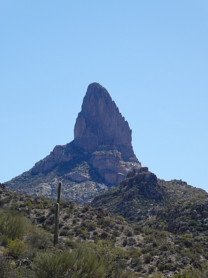
Not-so-short Shortcut by Steph_and_Blake  Overview OverviewQuarter Circle U Trail is a short (mileage, not time) bushwhack to the east of Palomino Mountain in the Superstitions that connects the Dutchman Trail (#104) to the Peralta Trail (#102). This description is to inform folks that might view this as a short-cut. Warning First: A long-sleeved shirt, long pants, and gloves are recommended. Also, good map-reading skills or a GPS unit are needed as it is not obvious where to leave/get on the Dutchman or the Peralta Trail. We took the Quarter Circle U Trail from the Dutchman Trail, headed in a southeast direction, and we could not see the Peralta Trail until some hikers above us passed on it.
Hike Head east on Dutchman Trail, go over Parker Pass. About 0.3 miles before Black Mesa Trail (#241) comes in from your left (north), go off-trail to your right, headed in a southerly direction. You start on a lightly cairned and slightly overgrown trail. At this point, the hiking is pretty easy, but fairly soon, the trail vanishes, and you have to begin bushwhacking. Keep aiming for Weavers Needle and consult your map frequently. There are numerous side drainages you'll encounter, but stay in the main one and keep Palomino Mountain to your left. The goal is to pick the path of least resistance, which may sometimes be in the bottom of the drainage itself. We probably crossed the drainage ten times to avoid vegetation choke-points and the loose, steep hillsides. We reinforced or built cairns for the first 3/4-mile, but when it became obvious that we wouldn't recommend this trail to anyone, we abandoned our efforts. At about 1.2 miles in, leave the drainage, take a hard left (east) and climb up the rocky hillside. You might see a faint horizontal line of grasses that breaks up the hillside above you. That would be the Peralta Trail. Keep climbing until you reach it. The only positive thing to be said about this "short-cut" is that cholla was at a minimum. The views would have been far superior if we'd just taken the "longer" way around Palomino. Water Sources There were two small (less than 24 inches in diameter) pools of water in a side drainage coming in from the west. Camping We stumbled upon an old fire ring, but the surrounding, cleared area only looked big enough for a small tent. Given the lack of good views, we'd recommend camping elsewhere. Check out the Official Route and Triplogs. Leave No Trace and +Add a Triplog after your hike to support this local community. One-Way Notice This hike is listed as One-Way. When hiking several trails on a single "hike", log it with a generic name that describes the hike. Then link the trails traveled, check out the example. | ||||||||||||||||||||||||||||||||||||||||||||||||||||||||||||||||||||||||||||||||||||||||||||||||||||||||||||


