Route Editor

| Guide | ♦ | 6 Triplogs | 0 Topics |
details | drive | no permit | forecast | 🔥 route |
stats |
photos | triplogs | topics | location |
| 79 | 6 | 0 |
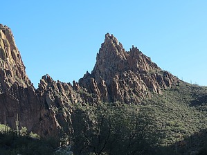
Not to be confused with its neighbor, Peak 2803 by John10s  Overview OverviewPeak 2830 overlooks La Barge Box Canyon and offers impressive and unique views of the canyon below, along with other western Superstition landmarks including Battleship Mountain, Geronimo Head, Malapais, and more. The majority of the hike is on-trail, with a ~0.6-mile steep, off-trail ascent after leaving Boulder Canyon Trail. Peak 2830 can be accessed via Boulder Canyon Trailhead at Canyon Lake Marina or First Water Trailhead. The official route described here begins from Boulder Canyon Trailhead, which is a round-trip hike of ~12.5 miles; starting from First Water Trailhead and hiking Second Water Trail to connect with Boulder Canyon is a little shorter, at ~11 miles round-trip. Check out the trip logs for alternate routes.
Starting from Boulder Canyon Trailhead, follow Boulder Canyon Trail #103. Before the trail descends into the canyon, you'll enjoy views of Battleship Mountain, Weaver's Needle, and the destination, 2830. From that angle, the peak looks like a narrow blade of rock towering over the entrance to La Barge Box, and reaching the summit looks like it will be very difficult. Around 4.2 miles in, you'll pass the intersection with Second Water Trail #236 as you continue on Boulder Canyon along the west side of Battleship Mountain. Past the southern end of Battleship, you'll get a better side profile of Peak 2830, and the approach looks more reasonable from that angle. A little over 5.5 miles in, leave the trail and start making your way up toward the peak. The approximate location where I found it easiest to start the off-trail portion was near 33.4861071, -111.3943418. Having the GPS route handy helps, but it soon becomes apparent that the most efficient route will take you to the small saddle on the ridgeline. The route becomes increasingly steep on the way up, and you'll start to get some nice views of Battleship as you gain elevation. The approach is rocky and loose in places, with quite a bit of brush in the mix, though most of it is not the thorny variety. You may need to do some light scrambling as you make the final climb up to the ridgeline. From there, Peak 2803 is to the south, and 2830 (unlabeled on the HAZ topo) is to the north. Continue north along the rocky ridgeline for a short distance, where you may encounter signs of big horn sheep--this seems to be a popular area for them. Finally, scramble up some darker boulders to stand on top of 2830. There's a small jar with a register inside, and you'll be rewarded with great views looking down the length of La Barge Creek and the eastern side of Battleship. Malapais dominates the eastern horizon, and you can look directly down into the otherworldly landscape of La Barge Box from the summit. Once you've enjoyed the peak, you can explore the ridgeline and check out the slightly lower Peak 2803 to the south, return the way you came and reconnect with Boulder Canyon Trail to hike out, or descend the eastern side of the ridgeline via a steep, brushy drainage to drop down into La Barge Box. Refer to the trip logs for several descriptions of that route; be warned that it's not a fast or simple approach. For those who want to visit La Barge Box via an easier route, return to Boulder Canyon Trail and follow the social trails that approach the southern end of Battleship, one of which will lead down to the box canyon. After leaving the canyon, you can follow La Barge Creek back to Boulder Canyon Trail. Check out the Official Route and Triplogs. Leave No Trace and +Add a Triplog after your hike to support this local community. | |||||||||||||||||||||||||||||||||||||||||||||||||||||||||||||||||||||||||||||||||||||||||||||||||||||||||||||||||||||||||||||||||||||||||||||||||||||||||||||||||||||||||||||