 Route Editor

| Guide | ♦ | 1 Triplog | 0 Topics |
details | drive | no permit | forecast | route |
stats |
photos | triplog | topics | location |
| 4 | 1 | 0 |
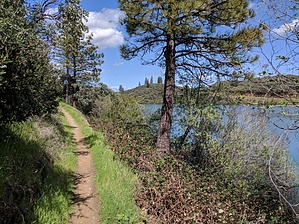
validated views by lojones5  This a short trail that follows the shoreline of the Keswick Dam reservoir, it is one of the oldest trails in the area. Warning One part of the trail can potentially be flooded if the river level is very high, but it is usually passable.
The trail begins right at the West end of Keswick Dam, where there is a sign indicating the name of the trail. It is a single track dirt trail that has views of the river/reservoir almost the entire way. At about 2/3 of a mile, the trail divides at a fork. Both options lead back to each other after a short distance. One stays closer to the river, and the other strays slightly away and is somewhat of a shortcut. After the two paths meet each other again, the trail continues uphill to meet up and end at the Sacramento River Rail Trail. At this end of the trail, there is an uphill power line road that can be followed for a hundred yards or so for a nice view of Mt. Lassen and a panorama of the river and Keswick Dam. Check out the Official Route and Triplog. Leave No Trace and +Add a Triplog after your hike to support this local community. One-Way Notice This hike is listed as One-Way. When hiking several trails on a single "hike", log it with a generic name that describes the hike. Then link the trails traveled, check out the example. | |||||||||||||||||||||||||||||||||||||||||||||||||||||||||||||||||||||||||||


