 Route Editor

| Guide | ♦ | 1 Triplog | 0 Topics |
details | drive | no permit | forecast | route |
stats |
photos | triplog | topics | location |
| 14 | 1 | 0 |
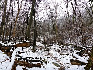
Walking in a Winter Wonderland by kingsnake  In any case, describing the hike itself...
The Mason-Dixon line, just across the railroad tracks, is signed and has a trail log. Immediately afterwards, the AT crosses PA-550 and descends to Falls Creek (0.8 mi). Like all the creeks on this hike, at least in April it had plenty of water. The AT climbs 650 in the next mile, almost to the top of Mount Dunlop, the only climb of this hike. (The rest are rolling up & downs of 100-200 ft., at least heading north.) Halfway up, the AT crosses Buena Vista Rd. There are blind curves either side, so keep an eye out for traffic, despite it being a minor road. Also keep an eye out for where the AT continues on the north side of the road: It's easy to miss. "Summiting" Mount Dunlop, and continuing on to the Blue Ridge Lookout Tower will add about 0.75 miles and 200 AEG to your hike. From Mount Dunlop to entering the Michaux State Forest (3.40 mi.), the Appalachian Trail crosses four roads and one creek, Red Run. Three of the roads are paved, including heaviy trafficked PA-16. The dirt road, Rattlesnake Run Rd., is the back road into Old Forge. Just north of Rattlesnake Run Rd., there is an unnamed spring. Deer Lick Run Shelter (4.8 mi.), is two small three-sided, single-story, shelters. There is a small metal stove, two camp fire rings, two levelled tent stands, a spring, a privy, and no bear box. A half mile past the shelter, the AT descends 650 ft. in about two miles to Old Forge. The trailhead is in the town park, just north across several more creeks, including the East Branch of Antietam Creek. There is another trail shelter on the south bank, opposite the park, but I did not check it out. Doing an out & back, would double the distance -- duh -- and be about 2,800 AEG. Unlike the Maryland AT segments, between Pen Mar and Old Forge, the trail is very rarely rocky, and even then only mildly so. Even in very wet & snowy conditions, the surface holds up well, never getting too muddy. Check out the Official Route and Triplog. Leave No Trace and +Add a Triplog after your hike to support this local community. One-Way Notice This hike is listed as One-Way. When hiking several trails on a single "hike", log it with a generic name that describes the hike. Then link the trails traveled, check out the example. | ||||||||||||||||||||||||||||||||||||||||||||||||||||||||||||||||||||||||||||||||||


